National Weather Service Text Product
AFOS product ESFDMX
Dates interpreted at 00:00 UTCDisplaying AFOS PIL: ESFDMX
Product Timestamp: 2025-02-27 13:46 UTC
Bulk Download
Bulk Download Help
This bulk download tool provides the NWS text
in a raw form, hopefully directly usable by your processing system.
You can either provide a complete 6-character PIL/AFOS ID or provide
the 3-character base ID (e.g., AFD). The start and end
dates represent 00 UTC for those dates. The Zip format is useful as
the filenames will have the product timestamp, which is useful for
when the product format has ambiguous timestamps.
690
FGUS73 KDMX 271346
ESFDMX
Probabilistic Hydrologic Outlook
National Weather Service Des Moines IA
746 AM CST Thu Feb 27 2025
...Spring Flood and Water Resources Outlook...
This flood outlook is for the NWS Des Moines service area. It covers
the time period for early March through early June 2025. It includes
the following rivers and their tributaries in north central, central
and south central Iowa...
Iowa, Cedar, Skunk, Des Moines, Raccoon, Nishnabotna, 102, Thompson
and Chariton Rivers
This outlook is the second in a series of three outlooks for the
spring flood season. The next outlook will be issued on March 13th.
Refer to the NWS Des Moines website for more information at
weather.gov/desmoines .
...Flood Outlook Highlights...
* The risk of minor, moderate and major flooding is near to below
normal at all locations.
* Future weather--especially including amount, frequency and extent
of precipitation--can be big factors in the spring flood threat.
* Maps and graphics concerning the risk of flooding are available on
the NWS Des Moines National Water Prediction Service (NWPS)
website at weather.gov/desmoines/water.
This outlook provides long-range probabilistic river outlooks for
river basins in the NWS Des Moines service area. This outlook is
divided into three parts--the first part for the probabilities of
minor, moderate and major flooding, the second part for high water
and the final part for low water.
In Table 1 below, the current (CS) and historical (HS) or normal
probabilities of exceeding minor, moderate and major flood stages
are listed for the valid time period.
CS values indicate the probability of reaching a flood category
based on current conditions.
HS values indicate the probability of reaching a flood category
based on historical or normal conditions.
When the value of CS is more than HS, the probability of
exceeding that level is higher than normal. When the value of CS is
less than HS, the probability of exceeding that level is lower
than normal.
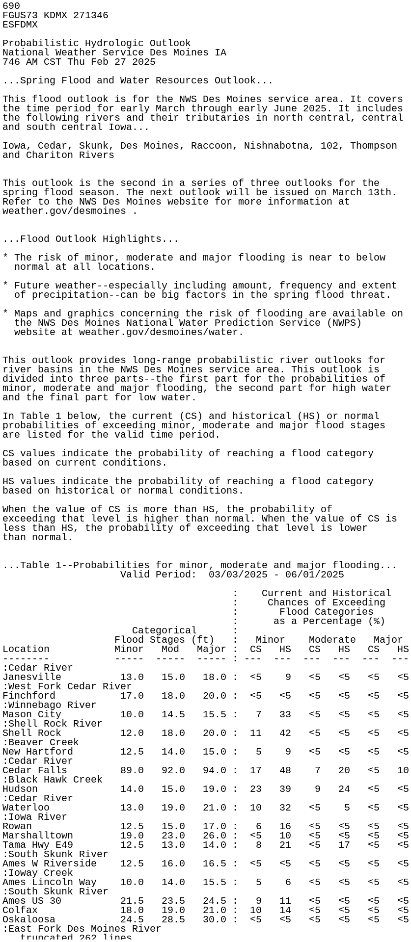
...Table 1--Probabilities for minor, moderate and major flooding...
Valid Period: 03/03/2025 - 06/01/2025
: Current and Historical
: Chances of Exceeding
: Flood Categories
: as a Percentage (%)
Categorical :
Flood Stages (ft) : Minor Moderate Major
Location Minor Mod Major : CS HS CS HS CS HS
-------- ----- ----- ----- : --- --- --- --- --- ---
:Cedar River
Janesville 13.0 15.0 18.0 : <5 9 <5 <5 <5 <5
:West Fork Cedar River
Finchford 17.0 18.0 20.0 : <5 <5 <5 <5 <5 <5
:Winnebago River
Mason City 10.0 14.5 15.5 : 7 33 <5 <5 <5 <5
:Shell Rock River
Shell Rock 12.0 18.0 20.0 : 11 42 <5 <5 <5 <5
:Beaver Creek
New Hartford 12.5 14.0 15.0 : 5 9 <5 <5 <5 <5
:Cedar River
Cedar Falls 89.0 92.0 94.0 : 17 48 7 20 <5 10
:Black Hawk Creek
Hudson 14.0 15.0 19.0 : 23 39 9 24 <5 <5
:Cedar River
Waterloo 13.0 19.0 21.0 : 10 32 <5 5 <5 <5
:Iowa River
Rowan 12.5 15.0 17.0 : 6 16 <5 <5 <5 <5
Marshalltown 19.0 23.0 26.0 : <5 10 <5 <5 <5 <5
Tama Hwy E49 12.5 13.0 14.0 : 8 21 <5 17 <5 <5
:South Skunk River
Ames W Riverside 12.5 16.0 16.5 : <5 <5 <5 <5 <5 <5
:Ioway Creek
Ames Lincoln Way 10.0 14.0 15.5 : 5 6 <5 <5 <5 <5
:South Skunk River
Ames US 30 21.5 23.5 24.5 : 9 11 <5 <5 <5 <5
Colfax 18.0 19.0 21.0 : 10 14 <5 <5 <5 <5
Oskaloosa 24.5 28.5 30.0 : <5 <5 <5 <5 <5 <5
:East Fork Des Moines River
Algona 17.0 18.0 22.0 : <5 26 <5 12 <5 <5
Dakota City 20.0 24.0 28.0 : <5 5 <5 <5 <5 <5
:Boone River
Webster City 14.0 17.0 19.0 : <5 <5 <5 <5 <5 <5
:Beaver Creek
Grimes 14.0 16.0 17.0 : <5 <5 <5 <5 <5 <5
:North Raccoon River
Jefferson 19.0 21.0 23.0 : <5 <5 <5 <5 <5 <5
Perry 15.0 18.0 20.0 : 33 51 11 33 <5 18
:South Raccoon River
Redfield 20.0 24.0 27.0 : <5 <5 <5 <5 <5 <5
:Raccoon River
Van Meter Hwy R16 17.0 22.0 23.0 : 9 20 <5 <5 <5 <5
Des Moines IA 28 36.0 38.0 40.0 : 8 13 <5 <5 <5 <5
Des Moines Fleur 12.0 16.0 25.0 : 25 52 9 21 <5 <5
:North River
Norwalk Hwy R57 22.0 25.0 26.0 : 11 18 <5 <5 <5 <5
:Middle River
Indianola 23.0 26.0 28.0 : 7 16 <5 <5 <5 <5
:South River
Ackworth 29.0 30.0 32.0 : <5 5 <5 <5 <5 <5
:Cedar Creek
Bussey 25.0 30.0 32.0 : <5 <5 <5 <5 <5 <5
:West Fork Des Moines River
Estherville 10.0 13.0 14.5 : <5 22 <5 8 <5 <5
Emmetsburg 11.0 13.0 15.0 : <5 18 <5 5 <5 <5
Humboldt 10.0 13.0 14.0 : <5 28 <5 <5 <5 <5
:Des Moines River
Fort Dodge 10.5 16.0 17.0 : <5 27 <5 <5 <5 <5
Stratford 19.0 25.0 27.0 : <5 18 <5 <5 <5 <5
Des Moines 2nd Av 23.0 26.0 30.0 : <5 <5 <5 <5 <5 <5
Des Moines SE 6th 24.0 26.0 30.0 : 24 49 7 18 <5 <5
Eddyville 63.0 68.0 70.0 : <5 7 <5 <5 <5 <5
Ottumwa 11.5 15.0 19.0 : 12 28 <5 <5 <5 <5
:Thompson River
Davis City 12.0 20.0 24.0 : 14 19 <5 <5 <5 <5
:South Fork Chariton River
Promise City 25.0 28.0 31.0 : 7 7 <5 <5 <5 <5
:Chariton River
Chariton 19.5 26.0 29.0 : 11 11 <5 <5 <5 <5
Moulton 36.0 37.0 38.0 : 7 8 5 5 <5 <5
:East Nishnabotna River
Atlantic 19.0 23.0 24.0 : 7 17 <5 <5 <5 <5
:East Fork 102 River
Bedford 24.0 25.0 26.0 : <5 <5 <5 <5 <5 <5
Legend
CS = Conditional Simulation (Current Outlook)
HS = Historical Simulation
ft = feet
In Table 2 below, the 95 through 5 percent columns indicate the
probability of exceeding the listed stage levels (in feet) for the
valid time period.
...Table 2--Exceedance Probabilities...
Chance of Exceeding Stages
at Specific Locations
Valid Period: 03/03/2025 - 06/01/2025
Location 95% 90% 75% 50% 25% 10% 5%
-------- ------ ------ ------ ------ ------ ------ ------
:Cedar River
Janesville 2.1 2.5 3.3 5.0 6.2 9.8 11.2
:West Fork Cedar River
Finchford 7.0 7.4 8.6 10.2 11.6 13.6 14.8
:Winnebago River
Mason City 5.1 5.2 6.1 7.6 8.6 9.6 10.7
:Shell Rock River
Shell Rock 8.3 8.6 9.2 10.2 11.1 12.1 13.2
:Beaver Creek
New Hartford 2.3 2.9 4.0 5.2 8.8 11.2 12.5
:Cedar River
Cedar Falls 79.6 79.8 81.9 84.9 87.0 91.1 92.5
:Black Hawk Creek
Hudson 6.9 7.4 8.9 11.5 13.8 14.7 15.5
:Cedar River
Waterloo 6.2 6.4 7.2 8.7 10.0 13.0 15.7
:Iowa River
Rowan 4.5 4.9 6.0 7.2 8.8 11.5 13.0
Marshalltown 10.6 11.0 12.3 14.0 16.0 17.5 18.7
Tama Hwy E49 2.3 3.0 5.4 8.5 10.2 12.2 12.8
:South Skunk River
Ames W Riverside 4.2 5.0 6.5 7.5 9.4 10.7 11.5
:Ioway Creek
Ames Lincoln Way 2.7 3.2 4.1 4.8 6.0 7.2 10.5
:South Skunk River
Ames US 30 11.6 12.9 14.9 16.5 18.7 20.9 22.5
Colfax 8.5 9.3 12.0 13.7 16.2 18.0 18.9
Oskaloosa 8.9 9.9 13.4 16.2 18.8 21.8 22.9
:East Fork Des Moines River
Algona 8.0 8.3 8.8 10.3 13.5 15.6 16.7
Dakota City 8.3 8.4 8.8 10.4 12.3 13.5 15.8
:Boone River
Webster City 3.5 3.7 5.0 6.7 8.4 9.6 11.0
:Beaver Creek
Grimes 3.5 4.8 6.3 8.2 10.7 11.8 12.6
:North Raccoon River
Jefferson 5.3 5.8 8.0 10.7 12.6 14.7 15.4
Perry 4.5 5.7 10.0 13.6 15.4 18.6 19.6
:South Raccoon River
Redfield 2.8 3.3 6.0 7.0 8.9 12.2 16.3
:Raccoon River
Van Meter Hwy R16 3.0 4.7 8.7 11.1 13.1 15.4 20.3
Des Moines IA 28 20.7 22.4 26.7 29.0 31.1 34.3 37.2
Des Moines Fleur 1.1 2.8 7.8 10.0 12.1 14.9 18.2
:North River
Norwalk Hwy R57 6.9 8.3 12.9 16.6 19.7 22.1 22.3
:Middle River
Indianola 8.7 10.1 14.5 15.9 18.1 22.2 24.0
:South River
Ackworth 8.1 9.6 12.0 13.6 19.5 24.5 28.9
:Cedar Creek
Bussey 5.5 7.8 10.7 14.0 16.2 20.6 22.3
:West Fork Des Moines River
Estherville 2.9 3.0 3.2 4.2 6.1 7.2 8.2
Emmetsburg 1.8 2.2 2.5 3.8 6.2 7.5 8.6
Humboldt 4.1 4.4 4.8 6.3 7.8 9.1 9.5
:Des Moines River
Fort Dodge 4.7 4.8 5.3 7.0 8.3 9.7 10.5
Stratford 6.8 7.0 8.8 12.0 14.1 16.7 18.6
Des Moines 2nd Av 13.9 14.1 15.9 17.7 18.8 19.3 19.9
Des Moines SE 6th 11.5 12.4 18.0 21.2 23.7 25.0 26.3
Eddyville 49.9 51.4 57.5 59.1 60.2 60.8 62.9
Ottumwa 2.4 3.5 7.8 9.6 10.5 11.9 13.5
:Thompson River
Davis City 1.2 4.1 4.8 6.4 9.7 14.6 18.3
:South Fork Chariton River
Promise City 5.4 8.2 14.0 18.4 21.6 22.8 26.0
:Chariton River
Chariton 12.4 14.0 15.0 16.7 17.8 19.8 21.4
Moulton 24.1 25.7 27.2 29.3 33.2 34.7 36.9
:East Nishnabotna River
Atlantic 2.2 3.8 5.5 6.6 9.6 15.0 19.8
:East Fork 102 River
Bedford 12.3 14.4 15.5 16.5 18.3 19.9 21.3
In Table 3 below, the 95 through 5 percent columns indicate the
probability of falling below the listed stage levels (in feet) for
the valid time period.
...Table 3--Non-Exceedance Probabilities...
Chance of Falling Below Stages
at Specific Locations
Valid Period: 03/03/2025 - 06/01/2025
Location 95% 90% 75% 50% 25% 10% 5%
-------- ------ ------ ------ ------ ------ ------ ------
:Cedar River
Janesville 0.4 0.4 0.4 0.3 0.3 0.2 0.2
:West Fork Cedar River
Finchford 0.2 0.2 0.1 0.1 0.1 0.1 0.1
:Winnebago River
Mason City 0.1 0.1 0.1 0.1 0.0 0.0 0.0
:Shell Rock River
Shell Rock 0.4 0.3 0.3 0.3 0.3 0.2 0.2
:Beaver Creek
New Hartford 0.1 0.1 0.1 0.1 0.0 0.0 0.0
:Cedar River
Cedar Falls 1.0 1.0 0.9 0.8 0.7 0.6 0.6
:Black Hawk Creek
Hudson 0.0 0.0 0.0 0.0 0.0 0.0 0.0
:Cedar River
Waterloo 1.1 1.1 1.0 0.9 0.8 0.7 0.6
:Iowa River
Rowan 0.1 0.1 0.1 0.0 0.0 0.0 0.0
Marshalltown 0.3 0.3 0.3 0.2 0.2 0.1 0.1
Tama Hwy E49 0.4 0.4 0.3 0.2 0.2 0.2 0.1
:South Skunk River
Ames W Riverside 0.0 0.0 0.0 0.0 0.0 0.0 0.0
:Ioway Creek
Ames Lincoln Way 0.0 0.0 0.0 0.0 0.0 0.0 0.0
:South Skunk River
Ames US 30 0.0 0.0 0.0 0.0 0.0 0.0 0.0
Colfax 0.1 0.1 0.1 0.1 0.0 0.0 0.0
Oskaloosa 0.3 0.3 0.3 0.3 0.2 0.1 0.1
:East Fork Des Moines River
Algona 0.0 0.0 0.0 0.0 0.0 0.0 0.0
Dakota City 0.1 0.1 0.0 0.0 0.0 0.0 0.0
:Boone River
Webster City 0.1 0.1 0.1 0.1 0.0 0.0 0.0
:Beaver Creek
Grimes 0.0 0.0 0.0 0.0 0.0 0.0 0.0
:North Raccoon River
Jefferson 0.1 0.1 0.1 0.1 0.0 0.0 0.0
Perry 0.2 0.2 0.1 0.1 0.1 0.0 0.0
:South Raccoon River
Redfield 0.1 0.1 0.1 0.1 0.0 0.0 0.0
:Raccoon River
Van Meter Hwy R16 0.3 0.3 0.2 0.2 0.1 0.1 0.0
Des Moines IA 28 0.4 0.3 0.3 0.2 0.2 0.1 0.0
Des Moines Fleur 0.4 0.3 0.3 0.2 0.2 0.1 0.0
:North River
Norwalk Hwy R57 0.1 0.1 0.1 0.0 0.0 0.0 0.0
:Middle River
Indianola 0.1 0.1 0.0 0.0 0.0 0.0 0.0
:South River
Ackworth 0.0 0.0 0.0 0.0 0.0 0.0 0.0
:Cedar Creek
Bussey 0.1 0.1 0.1 0.1 0.0 0.0 0.0
:West Fork Des Moines River
Estherville 0.1 0.1 0.1 0.1 0.1 0.0 0.0
Emmetsburg 0.2 0.2 0.1 0.1 0.1 0.1 0.1
Humboldt 0.2 0.2 0.2 0.2 0.1 0.1 0.1
:Des Moines River
Fort Dodge 0.3 0.3 0.3 0.2 0.2 0.1 0.1
Stratford 0.6 0.6 0.5 0.4 0.3 0.2 0.2
Des Moines 2nd Av 0.8 0.8 0.7 0.5 0.3 0.2 0.2
Des Moines SE 6th 1.2 1.2 1.0 0.8 0.5 0.4 0.3
Eddyville 2.1 2.1 1.8 1.2 0.6 0.4 0.3
Ottumwa 2.2 2.1 1.8 1.3 0.6 0.4 0.4
:Thompson River
Davis City 0.9 0.9 0.9 0.9 0.9 0.9 0.8
:South Fork Chariton River
Promise City 3.0 3.0 2.9 2.9 2.9 2.9 2.7
:Chariton River
Chariton 4.8 4.8 4.8 4.8 4.8 4.8 4.8
Moulton 18.8 18.7 18.7 18.7 18.7 18.7 18.7
:East Nishnabotna River
Atlantic 2.1 2.1 2.1 2.1 2.1 2.1 2.1
:East Fork 102 River
Bedford 10.6 10.6 10.6 10.6 10.1 9.6 8.8
These long-range probabilistic outlooks contain forecast values that
are calculated using multiple season scenarios from 30 or more years
of climatological data including current conditions of the river,
soil moisture, snow cover and 30- to 90-day long-range outlooks of
temperature and precipitation. By providing a range of
probabilities the level of risk associated with long-range planning
decisions can be determined. These probabilistic forecasts are part
of the National Weather Service National Water Prediction Service
(NWPS).
...Current Conditions as of February 16th 2025...
* River Levels...river levels are near to below normal for this time
of year.
* Soil Moisture...soil moisture is below to much below normal for
this time of year. Soil moisture values are approaching record or
near record low values for this time of year across the northern
third of the state.
* Snowpack...no snowpack existed. The seasonally warm temperatures
this week melted any remaining snow.
* Frost Depth...frost depth values are generally around 10 to 25
inches.
* Drought Conditions...Moderate Drought (D1) conditions exist
generally across the northwest two-thirds of the state. Abnormally
Dry (D0) conditions exist generally between that area and U.S. Hwy
34.
$$
Zogg