National Weather Service Text Product
Displaying AFOS PIL: SPSJAX
Product Timestamp: 2022-12-23 02:54 UTC
Bulk Download Help
This bulk download tool provides the NWS text
in a raw form, hopefully directly usable by your processing system.
You can either provide a complete 6-character PIL/AFOS ID or provide
the 3-character base ID (e.g., AFD). The start and end
dates represent 00 UTC for those dates. The Zip format is useful as
the filenames will have the product timestamp, which is useful for
when the product format has ambiguous timestamps.
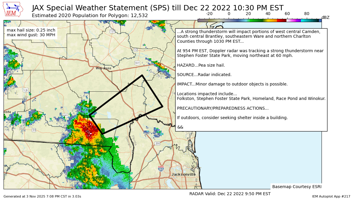
734
WWUS82 KJAX 230254
SPSJAX

Special Weather Statement
National Weather Service Jacksonville FL
954 PM EST Thu Dec 22 2022

FLZ024-GAZ152-165-264-350-364-230330-
Inland Nassau FL-Northeastern Charlton GA-Inland Camden GA-
Western Charlton GA-Brantley GA-Southern Ware GA-
954 PM EST Thu Dec 22 2022

...A strong thunderstorm will impact portions of west central Camden,
south central Brantley, southeastern Ware and northern Charlton
Counties through 1030 PM EST...

At 954 PM EST, Doppler radar was tracking a strong thunderstorm near
Stephen Foster State Park, moving northeast at 60 mph.

HAZARD...Pea size hail.

SOURCE...Radar indicated.

IMPACT...Minor damage to outdoor objects is possible.

Locations impacted include...
Folkston, Stephen Foster State Park, Homeland, Race Pond and Winokur.

PRECAUTIONARY/PREPAREDNESS ACTIONS...

If outdoors, consider seeking shelter inside a building.

&&

LAT...LON 3067 8230 3082 8242 3114 8193 3089 8174
TIME...MOT...LOC 0254Z 239DEG 53KT 3078 8229

MAX HAIL SIZE...0.25 IN
MAX WIND GUST...<30 MPH

$$

ENYEDI
Autoplot 217 generated the following image below. You may find more customization options , like removal of RADAR, for this image by visiting that autoplot.
