National Weather Service Text Product
Displaying AFOS PIL: SPSJAX
Product Timestamp: 2022-08-30 23:00 UTC
Bulk Download Help
This bulk download tool provides the NWS text
in a raw form, hopefully directly usable by your processing system.
You can either provide a complete 6-character PIL/AFOS ID or provide
the 3-character base ID (e.g., AFD). The start and end
dates represent 00 UTC for those dates. The Zip format is useful as
the filenames will have the product timestamp, which is useful for
when the product format has ambiguous timestamps.
178
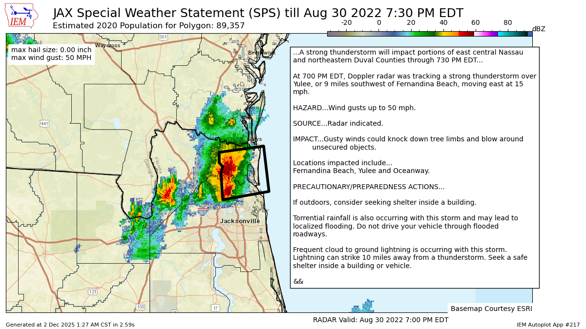
WWUS82 KJAX 302300
SPSJAX
Special Weather Statement
National Weather Service Jacksonville FL
700 PM EDT Tue Aug 30 2022
FLZ124-125-425-302330-
Western Duval FL-Coastal Duval FL-Coastal Nassau FL-
700 PM EDT Tue Aug 30 2022
...A strong thunderstorm will impact portions of east central Nassau
and northeastern Duval Counties through 730 PM EDT...
At 700 PM EDT, Doppler radar was tracking a strong thunderstorm over
Yulee, or 9 miles southwest of Fernandina Beach, moving east at 15
mph.
HAZARD...Wind gusts up to 50 mph.
SOURCE...Radar indicated.
IMPACT...Gusty winds could knock down tree limbs and blow around
unsecured objects.
Locations impacted include...
Fernandina Beach, Yulee and Oceanway.
PRECAUTIONARY/PREPAREDNESS ACTIONS...
If outdoors, consider seeking shelter inside a building.
Torrential rainfall is also occurring with this storm and may lead to
localized flooding. Do not drive your vehicle through flooded
roadways.
Frequent cloud to ground lightning is occurring with this storm.
Lightning can strike 10 miles away from a thunderstorm. Seek a safe
shelter inside a building or vehicle.
&&
LAT...LON 3045 8164 3058 8165 3061 8164 3063 8166
3068 8166 3071 8141 3049 8138
TIME...MOT...LOC 2300Z 264DEG 15KT 3060 8159
MAX HAIL SIZE...0.00 IN
MAX WIND GUST...50 MPH
$$
SHASHY
Autoplot 217 generated the following image below. You may find more customization options , like removal of RADAR, for this image by visiting that autoplot.
