National Weather Service Text Product
Displaying AFOS PIL: SPSJAX
Product Timestamp: 2020-06-28 01:45 UTC
Bulk Download Help
This bulk download tool provides the NWS text
in a raw form, hopefully directly usable by your processing system.
You can either provide a complete 6-character PIL/AFOS ID or provide
the 3-character base ID (e.g., AFD). The start and end
dates represent 00 UTC for those dates. The Zip format is useful as
the filenames will have the product timestamp, which is useful for
when the product format has ambiguous timestamps.
055
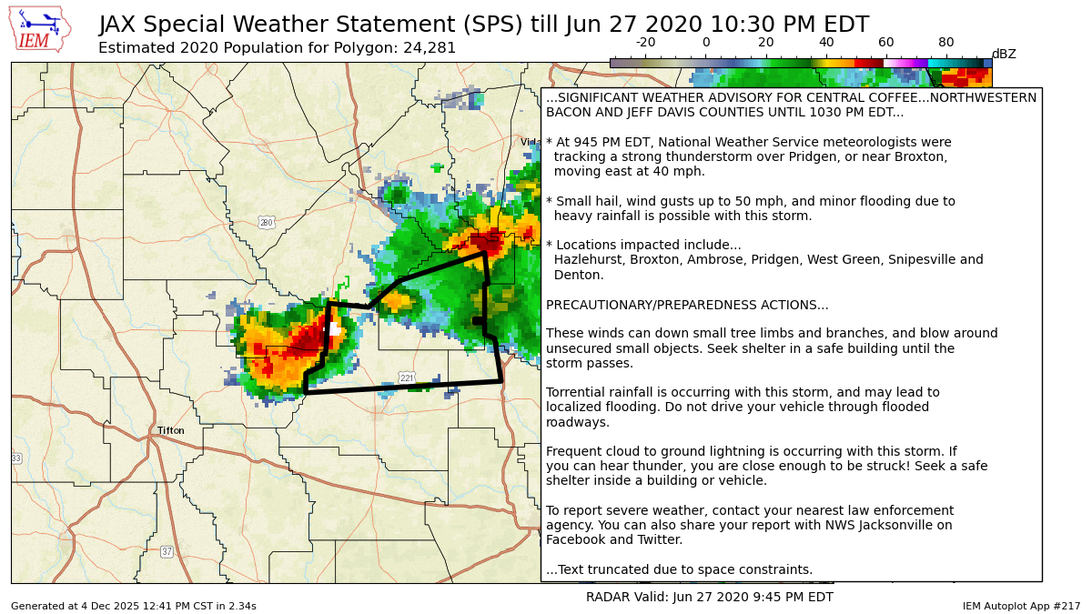
WWUS82 KJAX 280145
SPSJAX
Special Weather Statement
National Weather Service Jacksonville FL
945 PM EDT Sat Jun 27 2020
GAZ132>134-280230-
Bacon GA-Coffee GA-Jeff Davis GA-
945 PM EDT Sat Jun 27 2020
...SIGNIFICANT WEATHER ADVISORY FOR CENTRAL COFFEE...NORTHWESTERN
BACON AND JEFF DAVIS COUNTIES UNTIL 1030 PM EDT...
* At 945 PM EDT, National Weather Service meteorologists were
tracking a strong thunderstorm over Pridgen, or near Broxton,
moving east at 40 mph.
* Small hail, wind gusts up to 50 mph, and minor flooding due to
heavy rainfall is possible with this storm.
* Locations impacted include...
Hazlehurst, Broxton, Ambrose, Pridgen, West Green, Snipesville and
Denton.
PRECAUTIONARY/PREPAREDNESS ACTIONS...
These winds can down small tree limbs and branches, and blow around
unsecured small objects. Seek shelter in a safe building until the
storm passes.
Torrential rainfall is occurring with this storm, and may lead to
localized flooding. Do not drive your vehicle through flooded
roadways.
Frequent cloud to ground lightning is occurring with this storm. If
you can hear thunder, you are close enough to be struck! Seek a safe
shelter inside a building or vehicle.
To report severe weather, contact your nearest law enforcement
agency. You can also share your report with NWS Jacksonville on
Facebook and Twitter.
&&
LAT...LON 3192 8252 3184 8251 3184 8252 3175 8252
3175 8255 3174 8255 3174 8252 3171 8252
3170 8249 3159 8247 3156 8306 3161 8306
3163 8301 3166 8301 3166 8300 3179 8299
3178 8287 3184 8279 3185 8277
TIME...MOT...LOC 0145Z 262DEG 34KT 3170 8295
$$
HESS
Autoplot 217 generated the following image below. You may find more customization options , like removal of RADAR, for this image by visiting that autoplot.
