National Weather Service Text Product
Displaying AFOS PIL: SPSJAX
Product Timestamp: 2017-09-01 19:15 UTC
Bulk Download Help
This bulk download tool provides the NWS text
in a raw form, hopefully directly usable by your processing system.
You can either provide a complete 6-character PIL/AFOS ID or provide
the 3-character base ID (e.g., AFD). The start and end
dates represent 00 UTC for those dates. The Zip format is useful as
the filenames will have the product timestamp, which is useful for
when the product format has ambiguous timestamps.
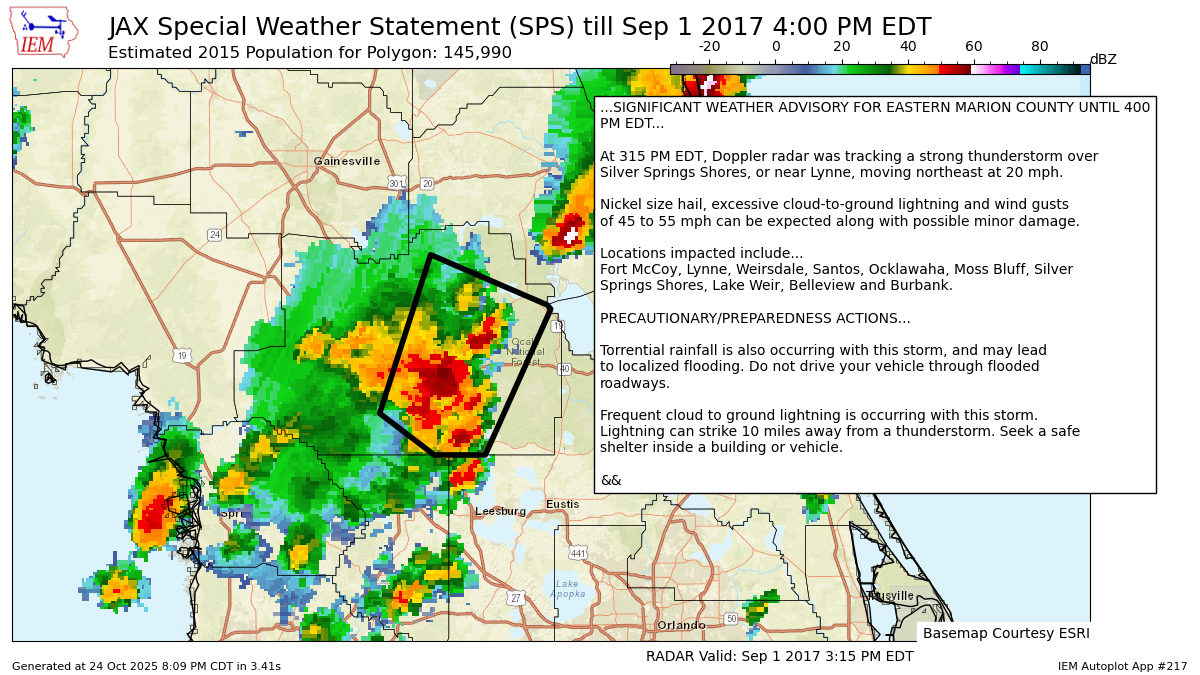
335
WWUS82 KJAX 011915
SPSJAX

Special Weather Statement
National Weather Service Jacksonville FL
315 PM EDT FRI SEP 1 2017

FLZ040-012000-
Marion FL-
315 PM EDT FRI SEP 1 2017

...SIGNIFICANT WEATHER ADVISORY FOR EASTERN MARION COUNTY UNTIL 400
PM EDT...

At 315 PM EDT, Doppler radar was tracking a strong thunderstorm over
Silver Springs Shores, or near Lynne, moving northeast at 20 mph.

Nickel size hail, excessive cloud-to-ground lightning and wind gusts
of 45 to 55 mph can be expected along with possible minor damage.

Locations impacted include...
Fort McCoy, Lynne, Weirsdale, Santos, Ocklawaha, Moss Bluff, Silver
Springs Shores, Lake Weir, Belleview and Burbank.

PRECAUTIONARY/PREPAREDNESS ACTIONS...

Torrential rainfall is also occurring with this storm, and may lead
to localized flooding. Do not drive your vehicle through flooded
roadways.

Frequent cloud to ground lightning is occurring with this storm.
Lightning can strike 10 miles away from a thunderstorm. Seek a safe
shelter inside a building or vehicle.

&&

LAT...LON 2906 8214 2944 8200 2932 8168 2931 8167
      2896 8185 2896 8199
TIME...MOT...LOC 1915Z 215DEG 17KT 2913 8199

$$

HESS
Autoplot 217 generated the following image below. You may find more customization options , like removal of RADAR, for this image by visiting that autoplot.
