Thundersnow coming?
Posted:
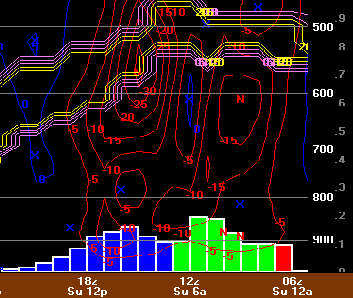
Local Bufkit guru Chris Karstens sent along a grid point time cross section for Ottumwa showing a very impressive setup for heavy snowfall taking shape on Sunday. The extreme amount of lift (depicted in red contours) is almost certainly convective and probably indicates a good chance for thundersnow. The image also depicts a period of moderate rain and freezing rain leading up to the heavy snowfall.
Voting:
Good = 19
Bad = 8
Tags: bufkit
Voting:
Good = 19
Bad = 8
Tags: bufkit