Past IEM Features tagged: spring

Spring Season Temp Trend
28 Mar 2024 05:30 AMThe featured chart presents yearly average temperatures for Ames during the spring season months of March, April, and May. A simple linear trend line is fit to the data and does not show much of a trend over these years for this period. Our start to spring 2024 got off to a very warm start, but has settled back into more seasonable temperatures. The forecast for the remainder of March looks to be warm again with a warm start to April expected as well. The featured chart does not include data for 2024 yet, but it would seem this year has a good chance to be above average versus the previous two that were not.
Voting:
Good: 7
Bad: 0
Tags: spring

Last Spring Temp Probs
22 Apr 2020 02:09 AMContinuing with the theme considering the frequency of experiencing cold temperatures yet this spring season, the featured chart presents the accumulated probability of having a sub threshold temperature after the given date. For example the values shown for 21 April indicate that just ~5% of years see a sub 22 degree low temperature after the date, ~10% below 26, ~25% below 28 and ~70% below 32. This chart nicely shows that the risks all dramatically decrease to below 50% by the first week of May for Ames. The forecast for the rest of April continues to be optimistic that warmer weather is here to stay, but as the probabilities show, having such cold temperatures in early May is not without precedent.
Voting:
Good: 9
Bad: 0
Tags: spring

How long till spring?
31 Jan 2020 05:34 AMA certain groundhog is set to make its prediction this weekend for how long until spring starts, so its appropriate to feature a more qualitative assessment of the date as shown by the featured chart. It presents the trailing 91 day average temperature for Ames. If one considers the start of spring to be the date when the 91 day trailing average starts to increase, which would denote the end of the coldest 91 day period of the year (winter), then we likely have around five weeks left to go. The middle panel shows date each year ending the coldest 91 day period along with a long term trend line fit. The fit is rather neutral with the simple average on 2 March. Well, let us see what the groundhog has to say!
Voting:
Good: 13
Bad: 2
Abstain: 1
Tags: spring

Been Spring for a Few Weeks
23 Mar 2018 05:30 AMThere are a number of ways to denote the start date of spring. Meteorological Spring consists of the full months of March, April and May. The Astronomical Spring is the period between the spring equinox and summer solstice and due to the Earth's eccentricity and leap days, the period is not exactly the same period of days each year. So we have either been in spring for a few days or a few weeks depending on how you count. Another way to compute the spring period is to split the year into 91 day chunks and then have spring start after the coldest 91 consecutive stretch of days ends. The featured chart does just that and shows the end dates of the coldest and warmest 91 day stretch each year. If you then back out the period of days between the coldest and warmest stretch, you end up with spring! The bottom two panels provide some long term metrics for the number of days and start date for Ames. This metric indicates spring starting on March 9th, so that's the answer!
Voting:
Good: 13
Bad: 2
Tags: spring

Last Trace
11 Apr 2016 05:34 AMOne of the things that makes spring time in Iowa problematic is that the period often features a number of snow storms in between stretches of nice temperatures that feel nothing like winter. The featured chart highlights the last trace plus snowfall reported by Des Moines for each year on record, how long that snowfall stuck around and the accumulated frequency of having it be the last snow of the season. So for April 11, approximately half of the previous years on record have at least one trace plus event after the date.
Voting:
Good: 9
Bad: 0
Tags: snow spring
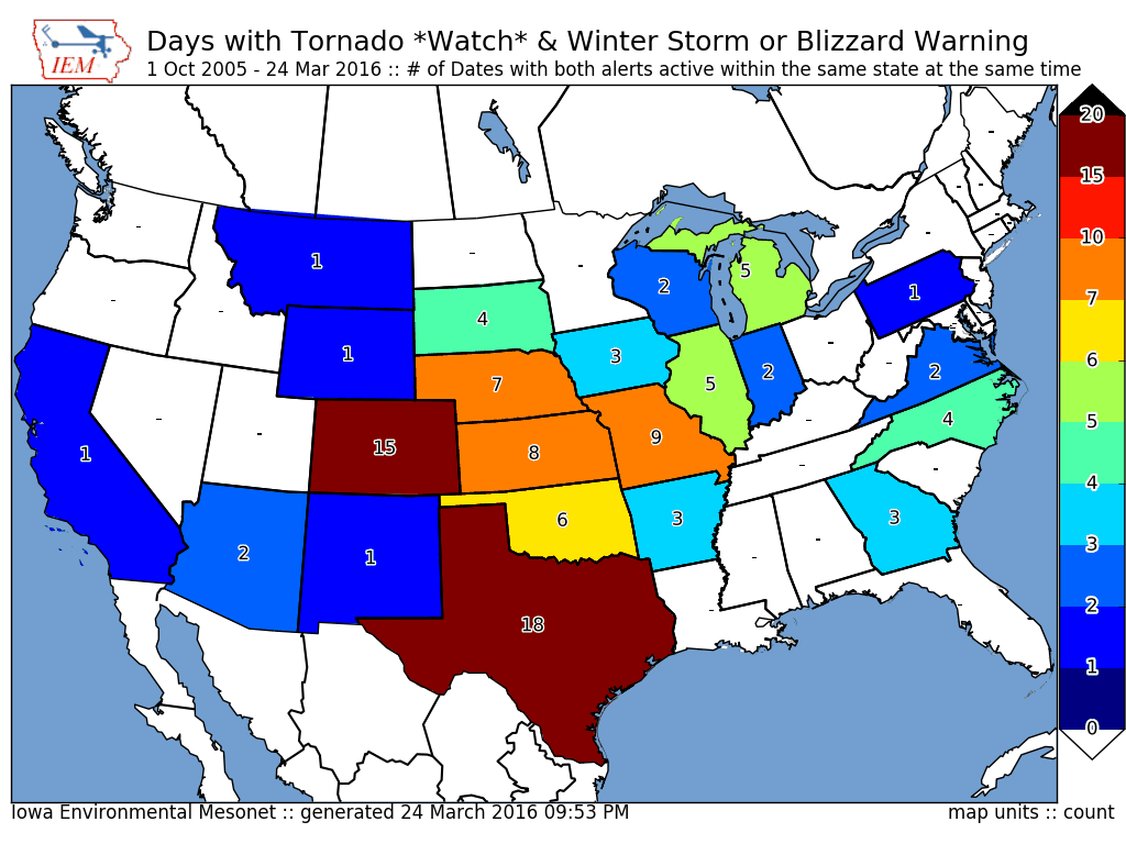
Two sided system
25 Mar 2016 05:34 AMSpringtime storm systems over the plains are often very energetic feeding off the large temperature contrast in air masses present over the United States. While the southern portion of the storm system can feature severe thunderstorms, the northern portion can feature heavy snowfall and even blizzard conditions. On Wednesday, Iowa had both portions over the state at the same time with a Winter Storm Warning active over northern Iowa while southern Iowa featured a Tornado Watch. The featured map presents the number of days with such an event occurring since late 2005. On Wednesday, this combination happened in Iowa, Kansas, and Nebraska. In general, these events are most commonly found in Texas and Colorado.
Voting:
Good: 17
Bad: 1
Abstain: 2
Tags: tornado spring

Spring Starts Stats
26 Feb 2016 05:35 AMTemperatures are forecasted to warm nicely this weekend for another taste of spring (which assumes we are still in winter). But if you consider the coldest 91 day period for average temperature to be winter, then we started spring a week ago as shown by the featured chart. The top panel displays the trailing 91 day average temperature for Ames with the minimum value labeled for each of the past 2 years. This indicates that the average temperature this winter was ~10 degrees warmer than 2013-2014! The second panel displays the early date of the minimum in trailing 91 day temperature, the overall average is around 1 March with plenty of scatter in the plot. The final panel displays the number of days between the start of spring (as computed by this metric) and the start of the subsequent warmest 91 day period for the summer. There is a lot of variability shown in this plot as well!
Voting:
Good: 38
Bad: 33
Abstain: 33
Tags: spring
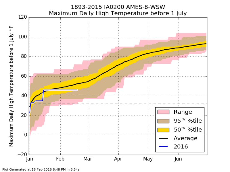
To date maximums
19 Feb 2016 05:36 AMTemperatures warmed nicely on Thursday, with some locations experiencing their warmest temperature so far this year. The featured chart displays the distribution of year to date warmest daily high temperature for Ames. The blue line represents the period to date this year with our warmest temperature on the cool side of long term average. The slope of the average curve really steepens into March as springtime and warmer weather becomes more established than in February. Today (Friday) will feel more like spring with highs even warmer than Thursday.
Voting:
Good: 45
Bad: 35
Abstain: 28
Tags: spring highs

Stepping Down
30 Sep 2015 05:36 AMSome of the coolest air this season has settled into Iowa overnight with temperatures stepping below previous lows for the fall season. The featured chart presents some diagnostics of these step downs in temperature with the 'step down' representing the setting of a new (since 1 July) cold temperature for the year. The average number of these events is around 19 for Des Moines, which is roughly one out of every ten days for the half year period. The second and bottom charts present histograms of the temperature levels and day of year whereby these steps occur. The increased frequencies at the start of July is an artifact of the algorithm, but there is a clear jump around mid September, which is about the time cooler air masses start arriving. There is also increased frequencies in the 50s, which is a temperature a bit lower than our supporting/typical 60 degree dew points in the summertime. There is also another jump just below freezing. These are levels that it takes a bit of time to push through as dew point and non-frozen soils offer resistance to cooling below those levels.
Voting:
Good: 7
Bad: 11
Abstain: 3
Tags: fall spring

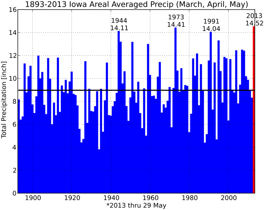
Spring Precipitation
05 Jun 2015 05:55 AMYesterday's feature presented the average spring season dew point and showed an increasing trend. Similarly, today's plot shows yearly spring season precipitation totals averaged over the state of Iowa and again, an increasing trend is shown. The right most bar on the plot would be this years total and it is slightly above long term average as well.
Voting:
Good: 33
Bad: 16
Abstain: 31
Tags: precip spring

Spring Starts Soon?
25 Feb 2015 05:43 AMWith winter storm warnings in effect for today and another round of very cold air set to arrive after the snowfall, it is difficult to imagine that spring time is almost here. The featured map looks at the end date of the coldest 91 day period based on daily climatology from NCDC. If you divide the year up into 4 equal length seasons (~91 days) and then compute the coldest stretch of 91 days, you could consider this to be winter. So once this stretch ends, you are then in springtime! This analysis shows that Iowa is only a few days from starting spring, but this year will be a bit different as a cold February and warm December will cause the coldest 91 day period this year to shift well into March.
Voting:
Good: 18
Bad: 5
Abstain: 3
Tags: spring

First 60
10 Mar 2014 05:34 AMSunday was a welcome relief from winter as high temperatures pushed well above the freezing point for Iowa. Even warmer weather is expected today with some locations hitting 60 degrees for the first time this year. The featured map presents the average date of first 60 degree temperature for the year along with the locations that have seen 60+ degrees so far this year. The impact of significant snow cover over the eastern half of the domain can be seen as areas that should have seen 60+ by now have not. The climatological gradient over Iowa is interesting as a month of time is shown from southwestern Iowa to northeastern Iowa.
Voting:
Good: 28
Bad: 2
Abstain: 2
Tags: 60 spring
Wettest Spring
30 May 2013 05:41 AMThe meteorological spring season includes the months of March, April, and May. All of the rain and snow these past three months have contributed to the what appears to be the wettest spring on record for Iowa as shown by the featured graph. The numbers shown are IEM estimates and differ from the official values from the State Climatologist due do differences in the areal averaging technique. Regardless, the preliminary estimates from the State Climatologist have this year as the wettest on record as well. We still have two days of May left and there are more chances of rain and severe weather.
Voting:
Good: 65
Bad: 13
Tags: 2013 spring

Waiting for spring
29 Mar 2013 05:40 AMHigh temperatures on Thursday were much closer to average than they have been recently. Many locations in the state have been below average since the start of spring last week. The featured chart presents the streak of days with a high temperature below average when the first day of spring was also below average for Waterloo. Years without a bar would indicate the first day of spring was above average for high temperature. For Waterloo, the streak this year is the longest since 1965, but should end today with highs expected in the mid 50s.
Voting:
Good: 84
Bad: 7
Tags: spring
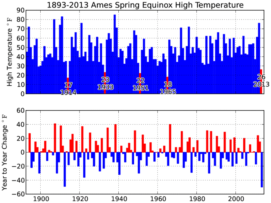
Cold Start to Spring
21 Mar 2013 05:39 AMYesterday was the official start of spring with the solar equinox, but did not feel like it as most of the state failed to rise above the freezing temperature mark. The featured chart displays the high temperature for the first day of spring each year for Ames. Only four other years were as cold as yesterday with the most recent year being in 1965. The bottom chart shows the year over year change with this year's change only rivaled by 1911-1912. The cold weather looks to stick around for the at least the next week with highs struggling in the 30s.
Voting:
Good: 23
Bad: 3
Tags: spring

When does spring start?
14 Mar 2013 05:33 AMYesterday's feature presented the end date of the coldest 91 day period of the year as a proxy for when spring starts. This was based on the daily climatology. The featured chart today looks at this metric in more depth. The top panel displays the past four years worth of trailing 91 day average temperature with the peak and trough labeled. The middle panel displays the yearly date of this minimum in 91 day trailing average (denoting the coldest 91 day period for the year). The bottom panel crudely displays the number of days during the "spring season, which is the number of days between the trough and peak minus 91 assumed days for the summer. So for this year and this metric, spring started on the 9th of March. The middle panel shows that this metric has not made it past the Ides of March since 1960! The bottom panel would indicate that our recent decade of spring seasons have been on the short side of long term trend.
Voting:
Good: 20
Bad: 5
Tags: spring

Did spring already start?
13 Mar 2013 05:42 AMAfter yet another snow storm and a day of blowing snow, many are hoping for spring! Has spring already come? The featured map presents the date that ends the coldest 91 day (one fourth of the year) period of the year based on NCDC climatology. If you use this metric to consider when "spring starts", the general pattern is for spring to arrive first over the west and progress eastward. Iowa's start date is shown to be the last week of February which means we are about on week three of spring already! Perhaps this is why spring seems so short as we go from winter into summer as snow storms are very common in Iowa for March, which is a spring month.
Voting:
Good: 24
Bad: 4
Tags: spring

Record Spring
04 Jun 2012 05:52 AMThe meteorological spring season (March, April, May) is complete and for average temperatures it was easily the warmest on record. The featured chart presents the spring season average high, high+low, and low temperature for each year since 1893 for Iowa. 2012 was not only the warmest year on record for this period, but by a rather large margin. This was thanks to the epic warmth in March. Our recent stretch of weather has seen its share of cooler than average days and the forecast for this week has us in the upper 70s and lower 80s for high temperatures.
Voting:
Good: 29
Bad: 3
Tags: spring 2012

Pleny of time for a freeze
27 Mar 2012 05:54 AMThe major concern at the moment is if we will see freezing weather again this spring. The warm winter and extremely warm March have provoked much of our vegetation to grow and a hard freeze now would damage the more sensitive crops. The featured chart presents the last day each spring that the temperature was below 32 and 29 degrees Fahrenheit. While there has been another year with such an early date of the last sub 29 degree day, it seems rather unlikely that we could go through all of April without a freezing temperature below 32. The immediate term forecast continues the warmth, but perhaps a big storm is brewing next week.
Voting:
Good: 20
Bad: 12
Tags: spring
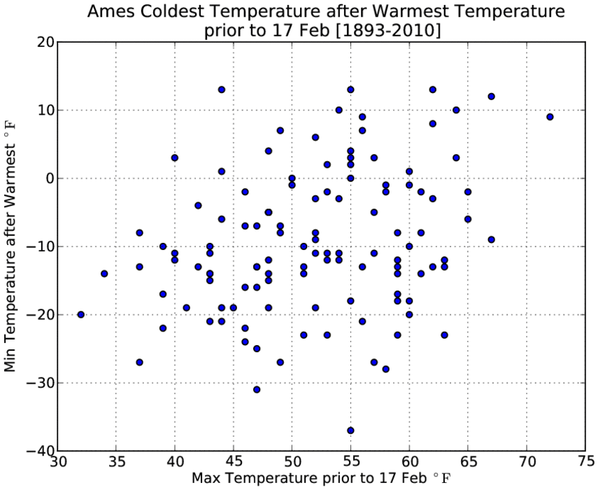
Cold air will return
17 Feb 2011 05:53 AMIt probably sounds like a "Debbie Downer" to point out that the very warm air today will eventually give way to much colder temperatures before spring is over. The featured chart presents the yearly combination of warmest temperature prior to 17 February and then the coldest temperature for the rest of spring after that day. In all cases, temperatures below 15 degrees have been observed with plenty of values below zero! Focusing back on the positives, warm and moist air is streaming into the state this morning with highs expected to top out in the 60s!
Voting:
Good: 14
Bad: 8
Tags: spring

About time for warmer air
14 Feb 2011 05:47 AMWow, after being stuck in winter for a period seeming like forever, the warmer air this past weekend sure felt nice and makes spring feel like it is not that far away. The featured chart presents the climatology of when the first occurrence of a temperature happens in the new year. The blue line can be thought of the earliest a given temperature has been observed and the red line would be the latest we have waited for a given temperature in a given year. The green line is the average date of the first observation. So for mid February, we'd expect to have seen at least one day in the lower 50s after 1 January. The turquoise line shows the pain that occurred last year when we had to wait until March to see a temperature above 40.
Voting:
Good: 30
Bad: 4
Tags: spring highs

Spring recoveries
05 May 2008 07:13 AMA chilly start on Sunday was quickly erased by bright sunshine and warm southwesterly winds. Temperatures recovered about 30 degrees, which is about what can be expected this time of year. The featured histogram is of observed difference between low and high temperature on 4 May including all sites in Iowa. The average is around 23 degrees. For Monday, we have a slighly warmer start with temperatures in the upper 40s, so adding 30 degrees to that will put us near 80!
Voting:
Good: 22
Bad: 13
Tags: spring