Past IEM Features tagged: nexrad

TVS Heatmap
27 Mar 2024 05:30 AMThis week is Severe Weather Awareness Week in Iowa with Wednesday's topic focusing on Tornadoes. There will be a statewide Tornado Drill at 10 AM. The primary mechanism the National Weather Service uses to analyze possible tornadoes is their NEXRAD Doppler RADARs. One of the products these RADARs produce is something called a Storm Attribute Table. The IEM maintains an archive of these with a download interface available. RADAR algorithms can generate a Tornado Vortex Signature (TVS) alert within this table output when rotation is detected with appreciable depth. The featured map presents a heatmap of these TVS reports with the individual NEXRAD locations denoted by a "X". This algorithm only works on RADAR information relatively close to the RADAR location, so thus why you see no-data gaps. There are other algorithms that can help diagnose possible tornadoes at further away distances, so the NWS is not completely flying blind over these areas. It is certainly much "easier" to see tornadoes on RADAR when it is close to the RADAR location.
Voting:
Good: 11
Bad: 0
Tags: nexrad

29 Years of NEXRAD Mosaics
06 Mar 2023 05:36 AMOne of the unique datasets that the IEM curates is a mosaic of NWS NEXRAD imagery. These spatially and temporally consistent mosaics provide a nice overview and allow for simple visual details on precipitation patterns over the US. The IEM has an archive of these mosaics dating back to 1995 with the featured map showing a postage stage presentation of the data for each year at 5 AM on 6 March. It is kind of neat to be able to quickly contrast the previous years with what is happening this morning. In fact, the RADAR this morning is about the most active for any year at this date and time since 1995!
Voting:
Good: 13
Bad: 0
Tags: nexrad
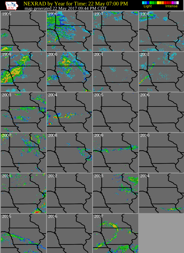
23 Years of RADAR Data
23 May 2017 12:39 AMShowers and a few thunderstorms returned to the state Monday evening. Of course having such storms is certain what one may expect for this time of year. The featured chart displays a NEXRAD composite for each of the past 23 years at 7 PM over Iowa. It is amazing to think we have such a long term record of NEXRAD data built-up now. RADAR data did exist prior to 1995, but the availability, formats, and legacy platform make it somewhat difficult to utilize today.
Voting:
Good: 12
Bad: 0
Tags: nexrad
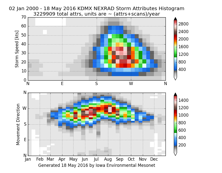
Storm Attributes
02 Jun 2016 05:35 AMThe most commonly seen product from a weather RADAR system is the base reflectivity map showing hydrometer concentration at the lowest elevation above ground (~ precipitation rate). The NWS NEXRAD system also runs algorithms on this data to track individual storm locations, intensities, and movements. The IEM archives these storm attributes and the featured image presents two histograms comparing storm speed vs direction and the direction vs week of the year. Of course, the majority of storms happen during the warm portion of our season, but the bottom chart also shows a shift in storm motion with spring and early summer storms traveling from the southwest and late summer storms traveling more from the west. This has to do with the dominate upper tropospheric flow patterns with the establishment of the southwestern monsoon season. The top chart shows that the dominate storm direction is from the southwest. Storms travelling from the north of west are slower moving. You can view this chart on this website for other NEXRAD locations in the US!
Voting:
Good: 10
Bad: 0
Tags: nexrad storm

Showers before Afternoon Severe
18 Sep 2015 05:35 AMThe severe weather threat forecasted for Thursday afternoon did not materialize due in part to morning storms that kept clouds around for much of the day. The featured chart attempts to look into the frequency of having showers in the state on days that have severe weather in the late afternoon. The chart presents the frequency that a given time in the morning to early afternoon has at least 5% of Iowa covered by RADAR reflectivity at or above 10 dBz (light showers). The chart is partitioned by month with the number of events and percentage of events without hitting this threshold denoted as 'No Storms'. This analysis would indicate that these severe weather events are not limited to days without showers in the morning hours. The largest non-storm values are in the summertime when larger scale forcing is the weakest and the need for solar heating is the greatest.
Voting:
Good: 25
Bad: 29
Abstain: 23
Tags: severe nexrad

Peak Reflectivity Time
20 Aug 2015 05:42 AMOn Tuesday, the IEM Daily Feature was a plot of average coverage of 35+ dbZ radar reflectivity averaged by day of the year. Today's feature displays the average coverage by week of the year and hour of the day. The top image being for the continental US and the bottom image for approximately just Iowa. For the CONUS, the peak time is clearly in the late afternoon hour during the summer, this represents the storms driven by the heating by the sun. For Iowa, there is a much different story to tell with the vast majority of peak coverages occurring during the early morning hours. These storms are thunderstorm complexes that roll into the state from the high plains and are feed by a phenomenon known as the low level jet.
Voting:
Good: 12
Bad: 7
Abstain: 5
Tags: nexrad
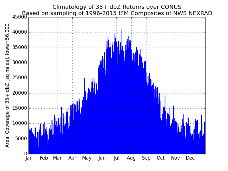
Peak Reflectivity
18 Aug 2015 05:37 AMA look at a nationwide composite of NWS NEXRAD RADAR information these past few days would show lots of scattered activity over the continental US. The featured chart looks at the climatology using the past 20 years of composite images of reflectivity returns at or above 35 dbZ. At this level and higher are your typical very rain showers and thunder showers. Summer clearly has the highest values with coverage values 3-4 times that of what we see during the winter season. The slope downwards is very steep as we start transitioning into fall during September. Thundershowers are currently visiting Iowa with more expected later today.
Voting:
Good: 11
Bad: 6
Abstain: 5
Tags: nexrad

Tornado Vortex Signatures
27 Jun 2013 05:01 AMThe National Weather Service RADAR network (NEXRAD) is constantly sampling the atmosphere and sensing objects that reflect its transmitted energy. The NEXRADs also measure the doppler shift of the reflected energy to provide an estimate of the reflected particles speed toward or away from the RADAR. Algorithms run on this information and organized storm motions are diagnosed. The featured map shows the location of tornado vortex signatures (TVS) diagnosed from the five RADAR sites covering the state. The TVS reported from the NEXRAD is a indication of a storm capable of producing or is already producing a tornado. Due to physical mechanics of doppler RADAR, these signatures can only be diagnosed at a range close to the RADAR. On the map, you'll notice many areas in Iowa without any reports. The reason is not that they don't have any tornados, but they are too far away from the closest RADAR for the algorithm to work.
Voting:
Good: 122
Bad: 25
Tags: nexrad

Storm Speed and Motion
07 Jun 2013 05:38 AMBesides the commonly displayed reflectivity and velocity presentations of RADAR, the NWS NEXRAD system is also running algorithms on this data attempting to identify and track storms. This information is disseminated as a product called Storm Attributes Table and comes with every volume scan. The IEM archives this product and the featured chart presents a summary of this information from the Des Moines NEXRAD. The histogram presentation shows the most common combinations of storm speed + motion and motion + day of the year. The vast majority of storms have a motion from the southwest moving to the northeast at a speed around 20-40 mph. The bottom chart shows the annual cycle of storm motion in Iowa. Storms transition from coming mostly from the WSW to WNW by late July and then back to mostly WSW. The physical reason is due to the synoptic scale flow patterns that change with the seasons.
Voting:
Good: 175
Bad: 22
Tags: nexrad storms

Bird Explosion
23 Mar 2013 04:13 PMThe Des Moines NEXRAD captured a fun phenomena of birds vacating an area in all directions forming a circle on RADAR. The featured image is from 11:50 AM this Saturday morning and the center of the circle appears to indicate the birds were staying at the Hendrickson Marsh Lake near Collins, IA.
Voting:
Good: 54
Bad: 9
Tags: nexrad birds

Interference
08 Dec 2011 05:59 AMThose of you that frequently look at weather radar have perhaps noticed a nearly persistent feature showing up over southern Iowa. The featured map presents the frequency of RADAR returns over 0 dBZ for most of yesterday. The red bar you see is coming from the Saint Louis RADAR and is the result of interference, perhaps coming from a nearby cellular phone tower. The map also shows blobs around the Des Moines and Davenport RADAR due to ground clutter (the RADAR beam hitting stuff on the ground and reflecting back to the RADAR). These types of phenomena make RADAR meteorology fun and a challenge to derive reliable products like precipitation estimates from reflectivity data.
Voting:
Good: 21
Bad: 5
Tags: nexrad

Chilling effects of rain and snow
03 Nov 2011 06:00 AMIowa got a preview of winter yesterday with some locations picking up their first measurable snowfall of the season. This was thanks to a process of cooling the air from having snow fall into warmer air near the surface and cooling it from phase change into rain. The more intense precipitation will lead to the strongest cooling rates and best chances of snow in these situations. The featured chart presents a comparison of average afternoon temperature against a composite of RADAR reflectivity. In general, the coolest temperatures are associated with the higher rates of precipitation.
Voting:
Good: 17
Bad: 1
Tags: nexrad

Little storm, big gusts
04 May 2010 06:07 AMA rather weak area of showers was able to produce strong winds Monday afternoon. The featured time series from Atlantic shows only weak NEXRAD returns producing wind gusts over 50 mph. The storms were able to push faster winds aloft to the surface via the rain and virga falling. This event was not isolated and occurred over a good portion of southwestern Iowa.
Voting:
Good: 27
Bad: 4
Tags: nexrad

Snow, wind, and roads
11 Dec 2009 06:10 AMThe featured chart looks back at the recent blizzard experience for the state and compares IEM estimates of State Patrol road travel advisories and closures with statewide estimates of mean wind speed and NEXRAD reflectivity coverage. The chart shows that the peak in snowfall coverage came before the maximum wind intensities. You can also see a very clear relationship between the improvement of road condition with the decrease in wind speed on Wednesday evening (Dec 9th).
Voting:
Good: 53
Bad: 14
Tags: blizzard road nexrad

Afternoon Showers
21 Aug 2009 06:02 AMA bit of late summer sunshine and some cool air overhead are often enough to fire off a few scattered showers and thunderstorms. The featured plot is a timeseries from Thursday of mean surface air temperature for Iowa along with the portion of the state covered by showers. The plot shows how the coverage of storms peaked late afternoon and rapidly diminished as the temperature cooled off as well (reducing instability). The same situation looks to repeat on Friday with near record minimum high temperatures expected!
Voting:
Good: 26
Bad: 16
Tags: nexrad

Another Hail Scar
13 Aug 2009 06:08 AMA few weeks ago, the result of a significant hail storm in Northeast Iowa was featured by showing the impact on vegetation. Another major hail storm left a similar scar over Central Iowa on Sunday and its effect can be seen as well. The featured image transitions from the Terra MODIS imagery to NEXRAD maximum reflectivity composite. Like with the previous feature, you can see the correlation between the highest reflectivites and the damage on the ground.
Voting:
Good: 20
Bad: 5
Tags: satellite nexrad hail

Impressive Hail Damage
30 Jul 2009 12:14 AMLast Friday, an extremely strong thunderstorm complex dropped a bunch of large hail over NE Iowa and SW Wisconsin. The NWS has an excellent summary of this event here and here. The featured image is a combination of Terra MODIS satellite for yesterday and maximum NEXRAD reflectivity for the event. The area shown initially in gray is unfortunately massive crop damage as the green leaves were shredded by the large hail and the area no longer appears to be lush green from space. You can see the streaks in the damage as the storms moved off to the southeast.
Voting:
Good: 39
Bad: 3
Tags: hail nexrad satellite

Ring of Fire
19 Jun 2009 06:12 AMThe featured image is a time composite of maximum NEXRAD reflectivity for Thursday showing what is commonly referred to as a "ring of fire". This is a result of a strong high pressure / ridge that suppresses thunderstorm development and shunts other storms to an arc surrounding it. This pattern pumps moist air from the gulf up into Iowa.
Voting:
Good: 48
Bad: 12
Tags: nexrad

Afternoon showers
07 May 2009 06:12 AMThe featured graph is a timeseries of the areal coverage of NEXRAD base reflectivity returns based on IEM generated composites. The values represent the percentage of the state covered by precipitation over time. Yesterday afternoon saw afternoon showers pop up due to daytime heating. This plot nicely shows how the peak coverage of storms occured around the time of peak heating from the sun (when the sun is the "highest" in the sky. Coverage amounts then decrease until sunset. More showers are expected today.
Voting:
Good: 41
Bad: 25
Tags: nexrad

15 years of data
01 May 2009 06:21 AMThe featured image presents the past 15 years of 6 AM NEXRAD composite on the first of May. Outside of a few light showers shown currently this morning, most of the years looked dry at this time. This image is a preview of a dataset the IEM is close to finalizing, close to one kilometer resolution NEXRAD composites at a 5 minute interval back to 1995! This dataset will at least provide lots of material for future features! :)
Voting:
Good: 34
Bad: 14
Tags: nexrad

Overcoming dry air
14 Apr 2009 06:15 AMA large storm system to our south on Monday brought rain and snow showers to Iowa. A considerable amount of dry air had to be saturated in order for the rain and snow to reach the ground. The featured graph is of 5 minute NEXRAD base reflectivity and temperature timeseries for Ames. The initial difference between the temperature and dew point begins to narrow once the shower passes overhead. The dew point increases as the air saturates and the temperature decreases as evaporation occurs.
Voting:
Good: 21
Bad: 6
Tags: nexrad

Streaks
24 Mar 2009 06:18 AMThe featured map is a time composite of maximum NEXRAD reflectivity. A large storm system to our west fired thunderstorms over the plains yesterday and the streaks show how the storm moved. Some of them moved northeast while others moved north or even northwest. The large system remains to our west this morning with another round of wet weather ongoing. The next storm system for the end of the week may bring heavy snowfall!
Voting:
Good: 36
Bad: 6
Tags: nexrad
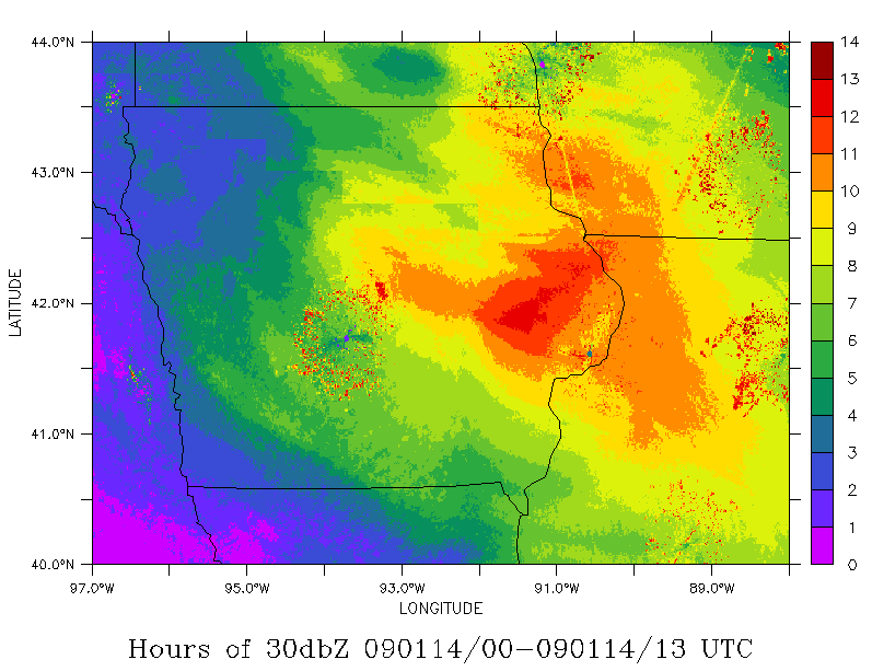
Another round of snow
14 Jan 2009 07:51 AMThe featured map is a time summary of NEXRAD reflectivity for a period of 6 PM Tuesday evening till 7 AM this Wednesday morning. The plot is the total amount of time during that period that a 30+ dbZ radar reflectivity was observed in the base composite generated by the IEM. The speckles in the plot indicate areas of persistent ground clutter (where the radar sees objects on the ground instead of rain/snow). The darker reds coincide nicely with an area that picked up 3-7 inches of snowfall over night.
Voting:
Good: 24
Bad: 4
Tags: nexrad

Stormy Pattern
24 Jun 2008 07:19 AMThe featured map is of max composite RADAR reflectivity for a 24 hour period ending 7 PM on Monday night. It is interesting to see how much of the country is currently experiencing stormy weather. Those of you that follow the Storm Prediction Center outlooks, you may have noticed the abnormally large slight risk areas recently.
Voting:
Good: 24
Bad: 10
Tags: nexrad
Swath of ice
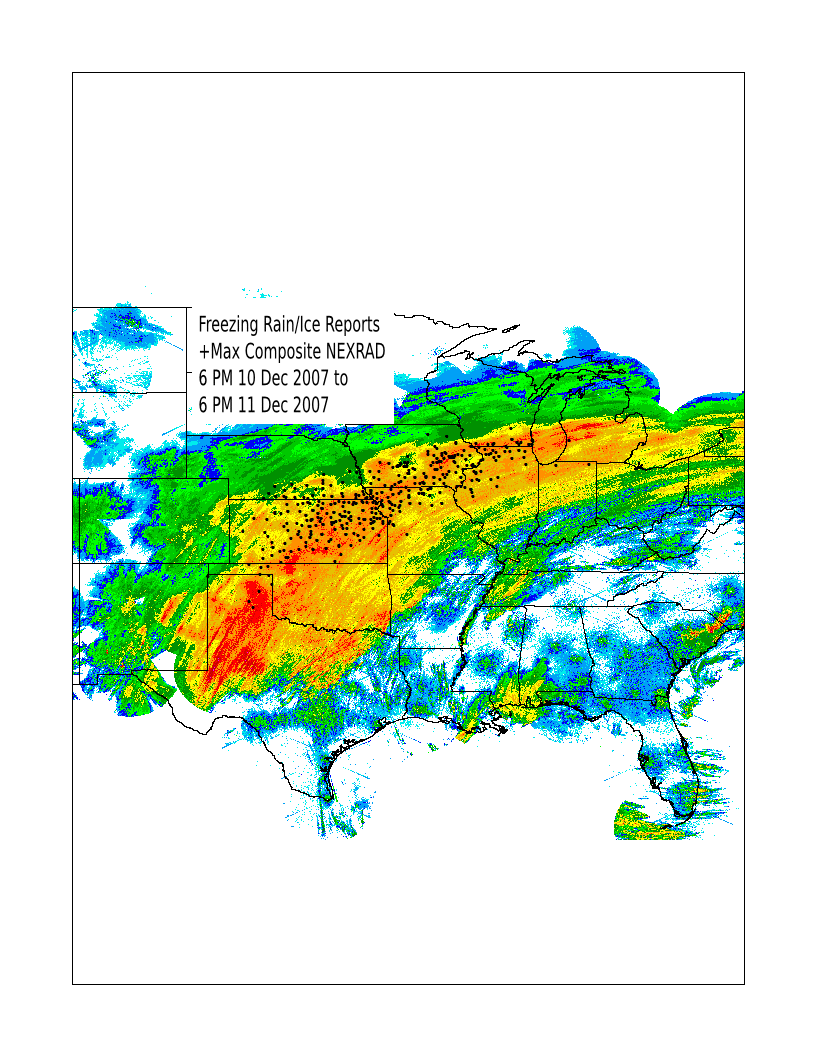
12 Dec 2007 05:13 AMThe storm system that brought freezing rain, sleet, and snow to Iowa has finally shifted off to the east this morning. A large area of the midwest from Oklahoma to Michigan saw significant ice accumulations. The featured map overlays freezing rain and ice reports on top of a max reflectivity composite from Monday. It is interesting to know how well these reports line up with the northside (the colder surface side) of the stronger NEXRAD reflectivities. Areas in green probably saw larger amounts of sleet or snow. You can find archives of these products on the iem, including the max reflectivity composite and GIS shapefiles of storm reports.
Voting:
Good: 14
Bad: 4
Tags: ice nexrad

Cold Pool
27 Jun 2007 07:23 AMThe featured animation is of a storm that fired just west of Des Moines on Tuesday and valid air temperatures from the SchoolNet. The guiding winds in the atmosphere are very light, so thunderstorms that develop will not last long as their downdraft occurs in the same spot as the updraft. This downdraft contains rain cooled air and when it hits the ground, it spreads out. Pay close attention to the air temperatures in West Des Moines as the thunderstorm is dissipating. The RADAR also shows a nice outline of the cold pool boundary as it pushes out away from the thunderstorm.
Voting:
Good: 25
Bad: 6
Tags: nexrad
View larger image
NEXRAD animation showing the storms firing during the daytime heating and dying at night
Instability showers
04 Jun 2007 06:52 AMCold air aloft and strong June sunshine helped to generate daytime showers and thunderstorms this weekend. Since the storms were driven by surface heating and in the presense of some vertical wind sheer, some of them produced brief funnel clouds as updrafts are stretched. Our weather maker is finally moving away today, but there are a number of distrubances forecasted to keep our weather unsettled this week.
Voting:
Good: 18
Bad: 12
Tags: nexrad

Inversion Fun
10 May 2006 06:57 AMDuring clear nights like last night, the ground and air near the surface will cool off creating a temperature inversion. When the inversion is strong, it will play havoc with EM waves from the NWS 88d RADAR. The beam will be refracted back toward the ground and start bouncing off objects like semi trucks. The featured image shows the result of this process with higher reflectivity values aligning with the interstate and highways. If the traffic motion is radial from the radar, you will also be able to see the traffic speeds in the doppler velocity data!
Voting:
Good: 53
Bad: 3
Tags: inversion nexrad
A Wild Sunday
07 Mar 2005 12:04 AMAfter complaints of March being boring, Mother Nature is working overtime this week to make things interesting. Sunday afternoon was very windy with record high temperatures and then a round of thunderstorms rolled through bringing lightning, small hail, and gusty winds. The highlighted animation shows the smoke plune from a large grass fire in Pottawattamie County. The strong winds and deep mixed surface layer quickly moved this smoke upwards to a reported 15,000 feet. The weather this week looks to be a bumpy ride, so hold on tight!
Voting:
Good: 15
Bad: 6
Tags: smoke nexrad
Tough Driving
22 Sep 2004 08:22 AMThis is always a bad time of year for driving near dawn and dusk. The sun rises directly east and sets directly west, which lines up nicely with many of our east-west roads. Des Moines RADAR indicated the sun rose directly east by the eastward pointing solar spike. About a year ago, I made this movie of the movement of the solar spike during sunset for the timeperiod of a year.
Tags: nexrad