Past IEM Features tagged: ice

Ice Storm Warnings
06 Dec 2013 05:46 AMThe big weather story for the country is the ongoing winter storm impacting the southern US. Significant accumulations of ice are occurring from Dallas northeast thru Memphis. The National Weather Service has an Ice Storm Warning issued for portion of Arkansas, Oklahoma, and western Tennessee. The featured map presents the number of ice storm warnings by NWS forecast zone since late 2005. These types of warnings are rather rare with the largest number issued being only 9. There are some caveats to this map as local NWS offices have choices on many types of winter storm products to issue. Some will issue winter storm warnings when the ice comes with snow as well. Regardless, these types of events occur over areas with strong temperature contrasts as warm air from the south overrides cold air from the north. Unfortunately, another winter storm will impact the area later this weekend and perhaps bring some snow to Iowa.
Voting:
Good: 81
Bad: 15
Abstain: 7
Tags: ice

Ice troubles
05 Jan 2009 06:05 AMIf did not take much rain on Saturday evening to turn Iowa's roads to a sheet of ice. The featured time series is from the RWIS site on US Highway 20 near Waterloo. The green line (dew point) tells the story of what happened to cause an icing event. Moist air was surging into the state on Saturday with air temperatures hovering just below freezing. Since the cold air was shallow and near saturation, rain was able to fall to the ground without much evaporation nor phase change and then immediately freeze as pavement temperatures were below freezing. The timing of this event late in the afternoon followed by a cold front passage both conspired to prevent most any melting over night. Cold temperatures on Sunday kept nearly all of this ice around on untreated surfaces.
Voting:
Good: 17
Bad: 10
Tags: ice rwis

Travel degradation
09 Dec 2008 06:24 AMThe featured animation is a time lapse of IEM delivered road conditions since Monday morning. The last few frames show the appearance of the orange color, which represents a travel advisory. More ice accumulation, wind, and snow today will continue to make travel very difficult.
Voting:
Good: 36
Bad: 6
Tags: ice

Icy trip home from Grandma's
01 Dec 2008 06:20 AMThe featured chart is from the Marshalltown RWIS on Sunday into Monday morning showing air temperature and 3 pavement temperatures. The plot shows pavement temperatures warming nicely during the day with air and dew point temperatures creeping above freezing (implying a lot of liquid water on the road way). By later in the afternoon, colder air moved in and you can see the rapid drop off of temperatures and also notice the little bump in pavement temperatures near freezing when some heat is released by the water freezing around 4 PM. Roads remain slick this Monday morning.
Voting:
Good: 16
Bad: 8
Tags: ice rwis
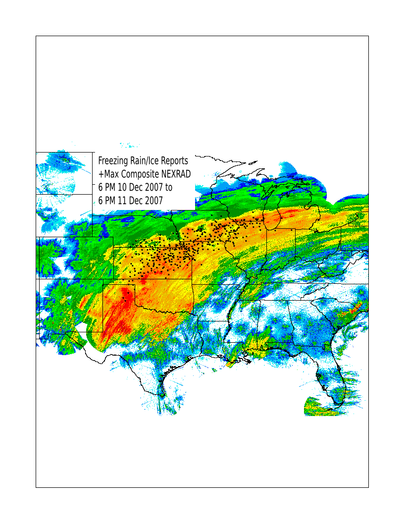
Swath of ice
12 Dec 2007 05:13 AMThe storm system that brought freezing rain, sleet, and snow to Iowa has finally shifted off to the east this morning. A large area of the midwest from Oklahoma to Michigan saw significant ice accumulations. The featured map overlays freezing rain and ice reports on top of a max reflectivity composite from Monday. It is interesting to know how well these reports line up with the northside (the colder surface side) of the stronger NEXRAD reflectivities. Areas in green probably saw larger amounts of sleet or snow. You can find archives of these products on the iem, including the max reflectivity composite and GIS shapefiles of storm reports.
Voting:
Good: 14
Bad: 4
Tags: ice nexrad

It's not easy being a tree
27 Feb 2007 07:29 AMIt has been a rough couple of years for trees in the Agronomy Building Courtyard on the Iowa State Campus. A wind storm in June 2005 and a weak tornado later that year only left a few trees standing. The recent ice storm has finished off one of the evergreens. Unfortunately, more freezing rain appears to be on the way thru Thursday which certainly will not be good for the trees already heavily weighted down.
Voting:
Good: 29
Bad: 3
Tags: ice