Past IEM Features tagged: wakelow
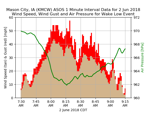
Saturday Wake Low
03 Jun 2018 02:22 PMOn Friday evening, a powerful cluster of thunderstorms developed into a Mesoscale Convective System and moved east and south bringing some much needed rainfall to southern Iowa early Saturday morning. These systems can have an expansive area of precipitation associated with them and sometimes this area can decay quickly leading to what happened on Saturday morning, a "Wake Low". This even was captured nicely by the Mason City Airport weather station and the featured chart presents one minute interval data from the event. These events are marked by rapid drops in pressure, which drive a rapid increase in wind speed. Sure enough, the chart shows the increase in wind while the pressure continued to drop and then moderation of the wind as the pressure returned to background state condition. Strong events like these, with winds gusts over 50 MPH, tend to do damage as was the case with wind damage reported over north-central Iowa.
Voting:
Good: 8
Bad: 0
Tags: wakelow

Gusty Wake Low
14 Jun 2011 05:54 AMA small storm complex make its way over Iowa on Monday dumping heavy rain and producing a fair amount of wind damage in its wake. This wind damage was from a strong "wake low" structure that can be seem by observing rapid pressure falls behind an area of precipitation. The featured chart is from the Colo KCCI SchoolNet station showing a rapid pressure drop along with increasing winds to over 65 mph. If you look carefully, you can see the absolute peak in wind speed (68 mph) occurred as the pressure reached its lowest value.
Voting:
Good: 19
Bad: 6
Tags: wakelow
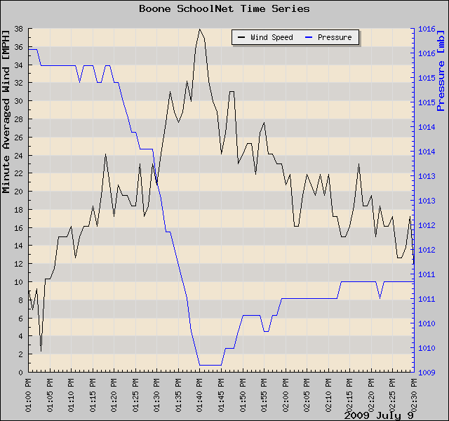
Windy wake low
10 Jul 2009 06:05 AMSometimes the winds experienced on the backside of a storm complex can be stronger than what occurs with the precipitation. The featured chart is a 1 minute interval timeseries from the United Community SchoolNet8 station east of Boone Iowa. The rapid pressure drop shown was associated with the backside of a thunderstorm complex to the south comprising a surface "wake low" structure. Wind speeds increased until when the pressure stopped dropping.
Voting:
Good: 27
Bad: 10
Tags: wakelow
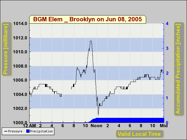
Interesting Pressure Traces
09 Jun 2005 07:48 AMSome of you may be curious about the odd jump and then dip on many of the 1 minute pressure traces recently. The featured plot shows a 2 hour period from yesterday afternoon at the Brooklyn SNET site. These plots are showing the meso-high and then wake low structures that often pass during severe convection. Here are some other examples from Colo, Montezuma, Charles City (10mb!), and Newton. If you look at those plots you can see the two distinct pressure patterns. A quick pressure jump (meso high), a return to the pressure before the jump (wave node), and then a rapid drop (wake low). Great stuff!
Voting:
Good: 9
Bad: 5
Tags: wakelow

Wake Low
21 Apr 2005 07:14 AMA strong wake low appears to have been detected by a number of IEM sites early afternoon on Wednesday. Eventhough the storms were to south of this feature, brief gusty winds were experienced. This phenemona was caused by rapid evaporation of cloud water from a decaying area of precipitation to the north and northwest of the squall line in southcentral Iowa. The evaporatively cooled air rushes to the ground and causes the large horizonal differences in pressure and thus wind! The plot shown indicates the rapid swing in pressure and the other plots show the increase in wind speed. Great stuff!
Voting:
Good: 14
Bad: 7
Tags: wakelow