Past IEM Features tagged: hurricane

Hurricane Idalia
31 Aug 2023 05:30 AMHurricane Idalia roared onshore Wednesday morning as a strong category 3 storm. For us Iowans, it is often difficult to appreciate the size of such storms when they are over geographies that are unfamiliar to us in scale. So the featured map takes the Tallahassee NEXRAD data at landfall and transposes the data as it was coming from the Des Moines NEXRAD location. So we find a system covering about two thirds of the state and whose eyewall covers a couple of counties. After the Derecho of 2020, comparisons were made to a hurricane and that Iowans got to experience what a hurricane is like. While this is somewhat a fair comparison for winds over a short period of time, this neglects the often more impactful storm surge, extreme rainfall totals, and winds that are sustained for much longer periods than the 30 minutes or so during the Derecho.
Voting:
Good: 15
Bad: 0
Tags: hurricane

Iowa Hurricane Weather
27 Sep 2022 05:30 AMIowa is thankfully a long and safe distance away from any land-falling Hurricanes. These powerful storms still impact our weather as shown by the featured chart. The chart presents relative to landfall averages for temperature departures and precipitation frequency for the five days before and five days after for Des Moines. The two charts partition these events by those hitting the US Gulf Coast and those hitting the US East Coast. The impact on precipitation appears to be negligible, but the temperature impact is more pronounced with gulf coast hurricanes seeing higher than average temperatures prior to landfall. The likely reason is an increase in downward motion and upper level ridging over our area with the approach of the gulf hurricane. Both of which tend to warm air temperatures. So it is somewhat interesting that the opposite (cooler than average temperatures) will be happening with Ian, but Ian is expected to hit western Florida and be moving eastward, which may be a part of the difference for our weather this time.
Voting:
Good: 10
Bad: 0
Tags: hurricane

Hurricane Zeta
29 Oct 2020 05:35 AMHurricane Zeta roared onshore over Louisiana on Wednesday afternoon as a category 2 hurricane. The featured RADAR mosaic is valid at about the time of landfall and shows a crazy combination of winter storm over the southern plains next to the hurricane. Iowa will miss out on any impacts from either storm as the both slide off well to our south and east. A dry stretch of weather is expected for Iowa over the next seven days which will provide some help for the agricultural crops yet to be harvested.
Voting:
Good: 14
Bad: 0
Abstain: 1
Tags: hurricane

Hurricane Laura
27 Aug 2020 02:32 AMAs if 2020 could not get any worse, Hurricane Laura came onshore around 1 AM this morning near Cameron, LA as a strong category 4 storm. This hurricane will rank as one of the most intense ever to make landfall over Louisiana. The Lake Charles, LA ASOS has reported a peak wind gust of 132 MPH, which is remarkable for an automated sensor to record. Sometimes these hurricanes can help bring rainfall to well inland places like Iowa, but this system will stay well to our south and eject quickly off to the east.
Voting:
Good: 17
Bad: 0
Tags: hurricane

Hello Dorian
02 Sep 2019 05:54 AMCategory 5 Hurricane Dorian continues its slow creep dangerously close to the Florida coastline this Monday morning. The storm and its eye are plainly seen on the IEM NEXRAD mosaic featured here. Questions remain on how close this storm will get to the US coastline and an small differences in east/west placement will make very large differences in impacts felt. The storm continues to currently ravage the Bahamas and other islands east of Florida where some locations will experience a day plus of hurricane conditions.
Voting:
Good: 8
Bad: 0
Tags: hurricane

Landfalling Hurricanes and Iowa
14 Sep 2018 05:34 AMHurricane Florence has taken its sweet time to make landfall on the eastern coast of the US. Do landfalling hurricanes impact Iowa weather? The featured chart attempts to address that question by looking at the average temperature departures and precipitation frequencies for Des Moines for a period of days relative to the landfall event. The charts are partitioned by if the hurricane made landfall on the east coast or gulf coast. While the magnitudes are small, a comparison of the impact on temperatures is interesting and would indicate that gulf hurricanes slightly boost temperatures and east coast hurricanes slightly dip temperatures. Our actual weather with Florence isn't exactly following this climatology as temperatures have been above average prior to its landfall. The impact on precipitation does not appear as obvious.
Voting:
Good: 10
Bad: 0
Tags: hurricane

Hurricane Florence
13 Sep 2018 05:42 AMThe eye of Hurricane Florence is now visible on the US NEXRAD composite generated by the IEM. The storm is of great concern for the southeastern US as it is expected to take its sweet time coming onshore and meander south during the process. While the maximum wind rating and thus the hurricane category has recently decreased, the storm is extremely large with a large area of tropical force winds. It will also be a prolific rainfall producer.
Voting:
Good: 11
Bad: 0
Tags: hurricane

Irma over Iowa
10 Sep 2017 06:11 AMAs was done a few weeks ago for Hurricane Harvey, today's featured image transposes Key West's RADAR data to Iowa to give some size perspective to Hurricane Irma. The image nicely shows extent of the eye wall, which would be bringing 100+ MPH winds all the way from Pella to Des Moines.
Voting:
Good: 5
Bad: 0
Tags: hurricane

Harvey Rain Rates
04 Sep 2017 06:27 AMThe featured table presents an analysis of available one minute interval precipitation observations from ASOS sites near Hurricane Harvey in Texas. While the total column simply presents the six day precipitation total, the other seven columns show the computed hourly precipitation rate based on actual totals over the given period. The chart shows some mind blowing rates experienced of over ten inches per hour at the one minute timescale and even over four inches per hour on the hourly time scale.
Voting:
Good: 8
Bad: 0
Tags: hurricane precip

Harvey Tornado Warnings
28 Aug 2017 04:24 AMTropical Storm Harvey continues to absolutely pound SE Texas. While the mind blowing amounts of rain have, rightly so, garnered the vast amount of public attention, Harvey has also produced an extreme number of storms warranting tornado warnings. The NWS Houston office has been at the epicenter of this and has issued a prodigious amount of warnings over the past three days. The featured chart displays IEM computed maximum number of tornado warnings issued over a three day period. The chart also displays the maximum number for the local Iowa offices between 1996 and 2017 for comparison. Even just considering the 73 warnings issued on Sunday by Houston, this total is substantially higher than anything here in Iowa over all three days combined.
Voting:
Good: 8
Bad: 1
Tags: hurricane

Harvey in Iowa
26 Aug 2017 03:16 PMHurricane Harvey roared onshore last night as a Category 4 storm. While the initial storm surge and extreme winds have subsided, day upon day of heavy rains are expected in the area as the storm takes its sweet time to move north. For the sake of perspective for us Iowans, the hurricane as depicted by Corpus Christi, TX NEXRAD last night is shown transposed into Iowa as if it was observed from the Des Moines NEXRAD. The scale of such storms is remarkable!
Voting:
Good: 11
Bad: 0
Tags: hurricane

Hurricane Harvey
25 Aug 2017 05:40 AMIt has been over 10 years since a major hurricane (Category 3 or higher) has made landfall on the United States. While technically still a Category 2, Harvey appears to be strengthening this morning and may make Category 3 strength before landfall. Regardless of the category, tremendous amounts of rain and storm surge are expected to bring significant issues to Texas and Louisiana.
Voting:
Good: 15
Bad: 0
Tags: hurricane

Hurricane Matthew
07 Oct 2016 05:46 AMThe saga of Hurricane Matthew continues this morning with the center of Hurricane just off the eastern Florida coastline. The featured map displays NEXRAD composite reflectivity this Friday morning with the classic presentation of a hurricane shown. The forecasted track of this storm continues to be tantalizingly close to the coastline with even a 10 mile difference in track making a tremendous difference in impact. Hopefully the track goes further offshore and folks are spared the worst of the storm.
Voting:
Good: 17
Bad: 0
Abstain: 1
Tags: hurricane

Hurricane Sandy
29 Oct 2012 05:10 AMWhile living in the here and now, it is sometimes difficult to grasp the historic event that is unfolding with Hurricane Sandy. Sandy will be associated with infamous names like Andrew, Camille, Hugo, and Katrina. The featured image displays a visual comparison of forecasts from the National Hurricane Center and the track of Sandy up until this morning. The track does not tell the whole story of the size and impacts from this storm system that are being felt from Maine to Florida and to the west even to Chicago!
Voting:
Good: 18
Bad: 2
Tags: hurricane

Hurricane Irene
28 Aug 2011 05:28 PMHurricane Irene hit the east coast of the US this weekend bringing flooding rains and significant storm surge. The eye of the hurricane came ashore Saturday morning close to Morehead City, North Carolina. The featured chart is of one minute interval ASOS data from airport sensor in town. The one minute interval data was not available after about 11 AM local time. The traces nicely show the change of wind direction as the eye passes overhead along with the decrease in wind speed. This station was chosen for this plot as it had the lowest pressure reported among the automated sensors the IEM collects data from in the area.
Voting:
Good: 18
Bad: 13
Tags: hurricane eye

Its name is Earl
03 Sep 2010 06:05 AMHurricane Earl is working its way up the eastern coast this morning, but appears it will not directly hit land until it weakens to a tropical storm. The featured map displays peak wind gusts reported thus far in North Carolina and values have yet to reach hurricane strength.
Voting:
Good: 41
Bad: 5
Tags: hurricane

No me gusta Gustav
01 Sep 2008 07:18 AMHurricane Gustav is very close to making landfall this Labor Day morning along the Lousiana coast. This system is expected to slow down and produce large amounts of rainfall. Eventually, this system will work north and bring some rain to Iowa.
Voting:
Good: 16
Bad: 11
Tags: hurricane

Tropical Storm Fay
19 Aug 2008 06:33 AMTropical Storm Fay came ashore in Florida this morning just under hurricane strength. Fay is expected to emerge on the Atlantic Coast side of Florida and perhaps stregthen to a hurricane. The storm system is expected to bring much needed rainfall to areas that have been dry this year.
Voting:
Good: 20
Bad: 10
Tags: hurricane

Hello Dolly!
23 Jul 2008 06:25 AM(Hard to pass up not using that feature title.) Dolly is a strong category 1 strength hurricane that is expected to make landfall along the Texas coast today. NEXRAD composite imagery shows the well defined eye and a tornado watch is in effect for the right front quadrant, which is favored for tornado development during landfall. The primary impact looks to be extremely heavy rainfall as the system moves slowly west. Sometimes these systems will eventually work their way toward Iowa, but the steering currents in the atmosphere do not favour that path.
Voting:
Good: 24
Bad: 9
Tags: hurricane

Hurricane Wilma
24 Oct 2005 07:14 AMHurricane Wilma made landfall this morning near Cape Romano packing winds up to 125 mph. The featured plot shows peak gusts from the Florida ASOS network up till 7 AM this Monday morning. Wilma is in a hurry and will be well east of Florida by later this afternoon.
Voting:
Good: 16
Bad: 4
Tags: hurricane

Hurricane Rita
23 Sep 2005 07:30 AMIt is going to be a long weekend for our friends along the gulf coast. Hurricane Rita is set to come onshore Saturday and slowly move north. The big story may be the tremendous amounts of rain (20+ inches) that may fall over the weekend.
Voting:
Good: 16
Bad: 8
Tags: hurricane

Hurricane Katrina
29 Aug 2005 07:00 AMHurricane Katrina is moving onshore early this Monday morning as a category 4 storm. An automated sensor in New Orleans has recorded a peak gust of 74 knots with the strongest winds expected later this morning.
Voting:
Good: 12
Bad: 6
Tags: hurricane

Hello Ivan
16 Sep 2004 08:25 AMIvan came ashore early this morning in grand fashion with a beavy of reporters standing in its way. Ivan will continue to weaken and move slowly to the NE dumping many inches of rainfall on folks in the SE US. The red box on this plot represents a tornado watch. Ivan has already produced deadly tornados in Florida.
Tags: hurricane
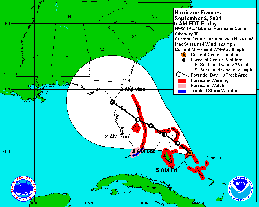
Waiting for Frances
03 Sep 2004 08:25 AMThe folks in Florida are counting down the hours until the arrival of Frances. This well advertised hurricane has prompted the evacuation of millions of people and is expected to do considerable damage with winds nearing CAT 4 strength. For Iowa, landfalling hurricanes usually mean that our weather slows down with storm systems finding it difficult to get to the East Coast.
Tags: hurricane


Lili Landfall
03 Oct 2002 08:26 AMHurricane Lili came ashore this morning packing winds of over 100 MPH. Like Isidore, this system will slide to our south and east. We are stuck between really warm air and really cool air with lots of clouds and good chances of rain.
Tags: hurricane

Isidore
26 Sep 2002 08:23 AMIn times like this, it is a good thing that Iowa does not have any ocean-front property. Tropical Storm Isidore moved on-shore this morning and is projected to stay SE of Iowa. Meanwhile, a cold front is parked in NW Iowa waiting for Isidore to pass before completing its trek across Iowa.
Tags: hurricane