Past IEM Features tagged: 2007
An extra foot
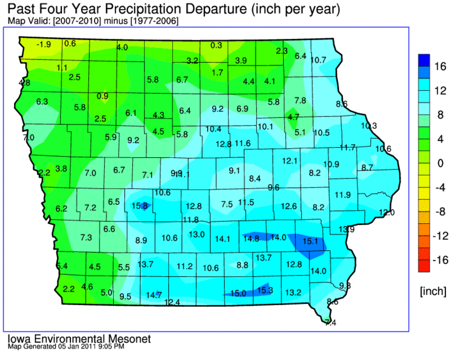
06 Jan 2011 05:51 AMYesterday's feature presented the last four years as being wetter than average statewide. The featured map compares these four years (2007-2010) against the 30 years previous to that. Please note that the units of this chart are inches per year, so a good portion of the state is shown with values in the 10-15 inches range. This means that the past four years have averaged 10-15 inches more per year than the average of the previous 30 years. Some portions of the state have not been as relatively wet and even a deficit appears in far northwestern Iowa.
Voting:
Good: 25
Bad: 2
Tags: precip 2007 2008 2009 2010

2007: Major Winter Storms
03 Jan 2008 07:35 AMAs rated by the IEM, the #3 weather event for 2007 was the series of winter storms that impacted the state in late Febuary and early March. The first brought a crippling ice storm and extreme snowfall amounts approaching 20 inches in Cresco. The second was a full blown blizzard shutting down the interstates in Northern and Western Iowa. Strong winds blew in both storms helping to bring down ice loaded power transmission lines. The featured image is a webcam show from the ISU Ag Farm showing a tractor and a backhoe up to its wheels in snow. The drift in front of this building was 9 feet high!
Voting:
Good: 20
Bad: 3
Tags: 2007

2007: Record cold in April
02 Jan 2008 07:11 AMAs rated by the IEM, the #2 weather event for 2007 was the extreme cold that visited the state in early April. The featured chart is from Lamoni showing temperates well below normal and well below freezing. Unfortunately, this caused major damage to the alfalfa and fruit crops who got an early start to the growing season thanks to mild weather previous to this period. For the period of April 4-15, average statewide temperatures (34.2 °F) were 2 degrees colder than any other year in our climate record since 1893. Temperatures quickly recovered after this period and frost was not seen again during the spring.
Voting:
Good: 12
Bad: 2
Tags: 2007

2007: Measured in feet
01 Jan 2008 12:49 AMThe featured map is estimated rainfall totals for 2007 based on NWS NEXRAD estimates. While the values may be somewhat over estimated, the story for 2007 was the extreme amounts of rainfall many parts of the state experienced with some locations over 4 feet of water! Much of this rain fell during the months of August and October, which for both months set many records for daily and monthly totals. The only portion of the state that missed out was the extreme Northwest corner. Will we see a repeat in 2008?
Voting:
Good: 15
Bad: 2
Tags: 2007

Lows are especially warmer
02 Nov 2007 07:28 AMThe featured graphs show the daily high and low temperatures reported by the Des Moines Airport ASOS along with climatology. Red colors depict observations above average and blue below. A cursory look at the plot indicates much more red on the low temperature graph and the raw numbers show a 3 degree warmer difference. This year is consistent with the recent yearly trend of warmer than normal temperatures with highs much closer to average than lows. In general, low temperatures are increasing the most statewide with the high temperature trend neutral to slightly negative over the past 10-20 years.
Voting:
Good: 24
Bad: 12
Tags: 2007

7th already, with 2 months left
23 Oct 2007 08:07 AMThe Des Moines Weather Bureau passed along a note that, statewide, 2007 is already 7th all-time for rainfall. It is probable that another couple of inches will fall placing 2007 in the top 5 when the year is out.
Voting:
Good: 18
Bad: 12
Tags: 2007

2007 heavy rainfall events
16 Oct 2007 12:00 AMGreater than 4 inches of rainfall over a 24 hour period were reported yesterday in a number of locations in Southwest Iowa. According to IEM databases, this is the 8th day this year with 2 or more COOP sites reporting 4+ inches of rain! The featured chart shows 2007 having 2 more days of heavy rainfall events than any other year since 1951. This statistic was computed only considering sites with an observational record back to 1951. Unfortunately, the result of this graphic has been numerous flood events over nearly all parts of the state.
Voting:
Good: 24
Bad: 5
Tags: 2007

Wet then dry, dry then wet
13 Jul 2007 07:29 AMIt has been a strange summer in Iowa as the rainfall fortunes of various locations in the state have switched from having too much to having not enough. The featured table shows how the sites that were wet in May are now dry in July, while Davenport has had the opposite occur. Regardless, the entire state could use rainfall, but the forecast is not that bullish on rain and an increase in temperatures will only add to the moisture stress that is already occuring.
Voting:
Good: 37
Bad: 17
Tags: 2007