Past IEM Features tagged: windrose

Gusty Tuesday
30 Mar 2022 05:34 AMWinds were gusty on Tuesday and not necessarily from a direction we'd expect to see such strong winds. The featured chart summarizes Tuesday wind data from the Ames Airport in the form of a wind rose. Wind roses are a beautiful way to present frequencies of both wind speed and direction within a polar axes plot which provides a compass orientation of the reports. The trickiest aspect is the meteorological convention of showing which direction the wind was blowing from. So the bars off to the ESE are winds blowing from the east-southeast and not toward the ESE. The segments within the bars show frequencies at a given wind speed interval. Such strong winds are more common from directions more south of SE or NW as you can find with climatology wind roses available on this website.
Voting:
Good: 14
Bad: 1
Tags: windrose

Clouds headed west
16 May 2018 05:34 AMThe observant weather watcher on Tuesday may have noticed the fair weather cumulus clouds headed west during the afternoon hours over central Iowa. This is somewhat rare as our winds aloft are generally blowing easterly. An easy way to assess the frequency of this happening is to look at wind roses for available upper air sounding sites. The featured image presents such a wind rose for Omaha at the 850 hPa level. This level is approximately where the clouds were on Tuesday. The 7 PM sounding from the site reported an east-northeast wind at that level and the wind rose would indicate this is the least frequent wind direction during May based on period of record data.
Voting:
Good: 8
Bad: 0
Tags: windrose sounding

80s in September
24 Sep 2014 05:38 AMThere is some hope that we'll reach 80 degrees later this week as our stretch of very nice fall weather continues. The featured wind rose presents the wind direction and speed frequencies when Ames September temperature is at or above 80. The dominate wind direction is clear with southerly winds the most common, which makes sense as it is our source of warmer air. The winds will be out of the south for much of the rest of the week, but speeds are not expected to be all that strong.
Voting:
Good: 11
Bad: 7
Abstain: 5
Tags: windrose sep

Snow and winds
04 Mar 2013 05:40 AMOur next winter storm system arrived overnight and has dumped a few inches of snow along with gusty east-southeast winds. Is it common to have snow being reported along with winds from the ESE? The featured chart presents a wind rose that summarizes observations from the Des Moines Airport when falling snow is also reported. The preferred direction is clearly NW. The least frequent direction is southwest, which is a wind direction that typically brings us warm weather and also implies a storm system center that is to our west and north due to how air flows around low pressure systems.
Voting:
Good: 51
Bad: 5
Tags: windrose snow

This explains a lot
21 Apr 2011 05:51 AMThe featured chart is a wind rose for observations reported so far this month from the Ames Airport. A wind rose nicely shows the summarized combination of wind direction and wind speed. The longer the bar is, the more common the wind has been from that direction. The chart shows the lack of winds from the SSE around to the west. These winds would be bringing warmer air into the state and make things feel more like spring. Our dominant directions have been ENE and NW, which is a cold and wet combination.
Voting:
Good: 20
Bad: 4
Tags: windrose

Explains our May
20 May 2010 05:11 AMThis featured wind rose is for Ames so far this May and provides insight into why we have been on the cool side of normal for temperatures. The shaded area highlights the lack of south and southwesterly winds. These winds are typically warm whereas easterly and northwesterly are cool. A return of these warm winds are expected this weekend with highs climbing well into the 80s!
Voting:
Good: 31
Bad: 1
Tags: windrose
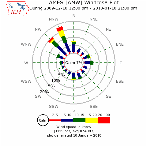
Northwesterly winds
11 Jan 2010 06:11 AMThe featured chart is a wind rose presentation of observed winds from the Ames Airport for the past 31 days. Wind roses show the frequency of direction and magnitude of wind. The dominance of northwest flow can be seen and that is one of the reasons our weather has been so bitterly cold for the past month. Changes are expected this week with winds out of the southwest, which are usually warmer.
Voting:
Good: 33
Bad: 6
Tags: windrose

No wonder it has been cool
10 Jun 2009 06:08 AMThe featured image is a wind rose for June from Esterville showing no reports of southerly winds so far this month. It is no wonder that temperatures have been on the cool side, since cooler air from the north continues to advect in. This pattern looks to continue into this weekend.
Voting:
Good: 38
Bad: 6
Tags: jun09 windrose

No wonder it is cold
02 Feb 2007 07:01 AMOur recent stretch of cold weather is not because the Chicago Bears are in the Superbowl this weekend. It is a result of rather persistent northwest flow pumping cold air our way from Canada. No better way to illustrate how persistent than with a recent wind rose plot showing the dominate 3 directions being NNW, NW, and WNW.
Voting:
Good: 30
Bad: 14
Tags: windrose

Wind roses
19 Jan 2007 07:29 AMA rose is a rose is a rose, except this rose! The featured image is a wind rose plot for the Des Moines airport for dates between 11 and 21 January. The plot is a wind climatology detailing frequency of wind direction and speed. The individual colors represent frequencies of observed wind speeds for 16 directions. The plot shows that winds from the Northeast and Southwest are rarely observed. The strongest wind speeds (20+ knots in red) are almost always from the Northwest, which is the most common wind direction. The plots of extremely valuable for designers who worry about wind transport of things like odor and particulates.
Voting:
Good: 40
Bad: 9
Tags: windrose