Past IEM Features tagged: heatburst
Heat Bursts
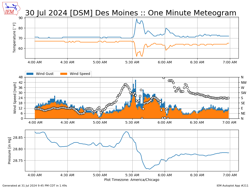
01 Aug 2024 05:30 AMHeat bursts are an interesting and sometimes damaging weather phenomena caused by decaying thunderstorms forcing air to the surface without precipitation. This air warms and dries as it descends. Such an event or maybe even multiple such events were observed by the Des Moines airport early Tuesday morning. The featured chart presents available one minute interval observations of temperature, dew point, wind speed, wind gust, wind direction, and pressure. The classic heat burst signature is shown with the rapid increase in temperature coincident with a rapid decrease in dew point along with a pressure response. The data seems to shown at least two or maybe even three different heat burst events! Fortunately, no known damage reports were associated with this event. Sometimes winds can gust to damaging magnitudes and/or the rapid increase in temperature can damage sensitive plants.
Voting:
Good: 10
Bad: 0
Abstain: 4
Tags: heatburst

3 AM Heat Burst
02 May 2022 05:30 AMAn interesting weather weather phenomena called a "heat burst" happened early Saturday morning over central Iowa thanks to a rapidly decaying area of precipitation. The featured chart presents one minute interval data from the Ames Airport between 3 and 5 AM on Saturday. Heat bursts are the rapid rise in air temperature along with drop in dew point associated with the transport of warming and drying air to the surface from rapidly decaying thunderstorms. The plot shows about a ten degree rise in air temperature along with about a five degree drop in dew point. The second panel shows another interesting phenomena appearing in the wind direction data (green dots) with an decaying oscillation likely associated with a wake low.
Voting:
Good: 20
Bad: 0
Tags: heatburst

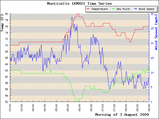
Monticello Heat Burst
29 Jun 2019 06:28 AM'Tis the season for compact and powerful Mesoscale Convective Systems (MCS) to frequent the state. Sometimes these systems can force air rapidly to the ground surface, which then heats the air thanks to compression. The result is a burst of hot and dry air known as a 'Heat Burst'. Such an event happened on Thursday behind a departing MCS over Monticello, IA (NE of Cedar Rapids). The featured chart presents the available observations and you can see the classic heat burst signature of a rapid warming of temperature and drop in dew point. These events can sometimes be damaging with extreme winds and blast furnace air damaging plants.
Voting:
Good: 19
Bad: 0
Tags: heatburst

Knoxville Heat Burst
24 Jul 2013 05:44 AMWhile the rain that fell on Monday evening was welcome, the storms also brought along damaging winds and some hail. The storms also produced a heat burst event, which was nicely captured by the Knoxville AWOS site as shown by the featured chart. Heat bursts are produced behind thunderstorm complexes as warm air is forced to the ground. This air continues to warm as it descends and since no water is being added, its relative humidity drops resulting in warm and dry air at the surface. The classic signature, as shown in the chart, is a rapid increase in temperature and decrease in dew point at a surface observation site. These events tend to be very windy as well with the site reporting a gust over 70 mph. Note that the chart would indicate the gust lasting for a number of minutes, but that is most likely a quirk with how wind gusts are reported by the sensor.
Voting:
Good: 45
Bad: 6
Tags: heatburst

Wichita, KS Heat Burst
29 Jun 2013 04:38 AMAn intense thunderstorm complex brought high winds to bear on Wichita, Kansas Thursday evening. A heat burst event followed shortly thereafter. The featured chart presents one minute interval temperatures and pressure from the Wichita Airport sensor. The classic heat burst signature is clearly shown as the rapid increase in temperature is paired with a rapid decrease in dew point. This is a result of very warm and dry air rushing to the surface. Click on the 'heatburst' tag shown with this feature to view other events the IEM has documented in recent years.
Voting:
Good: 218
Bad: 15
Tags: heatburst

Farnhamville Heat Burst
24 Jun 2013 06:26 AMA heat burst event occurred in Iowa on Sunday morning with the classic signature of having the temperature rapidly rise and dew point fall at the same time along with an increase in speed. The featured chart shows the heat burst event at the KCCI-TV schoolnet site in Farnhamville (near Fort Dodge). Please note that the 92 mph wind gust reported at the site is probably due to the sensors high location on top of a building. The wind sensor is not at a standard 30 foot and unobstructed height. These events are caused by rapidly decaying storms that drive a layer of warm air to the surface that warms even more thanks to the ideal gas law (increase in pressure leading to increase in temperature).
Voting:
Good: 90
Bad: 19
Tags: heatburst

Grand Island Heat Bursts
12 Jun 2013 05:33 AMPortions of southcentral Nebraska experienced an intense heat burst event during the early morning hours on Tuesday. The featured chart presents one minute interval observations from the Grand Island, Nebraska ASOS. Heat bursts are caused by decaying thunderstorms driving very warm and dry air to the ground. The classic signature is a rapid rise in temperature along with a rapid drop in dew point. The chart appears to show four heat burst events with the two after 5 AM being extremely intense as the temperature goes from the 70s to 100 degrees in a few minutes. These events tend to also bring gusty winds with some gusts over 50 mph reported in the area.
Voting:
Good: 112
Bad: 9
Tags: heatburst
Thursday Heat Burst Event
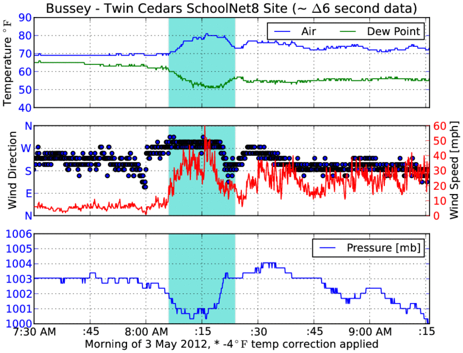
04 May 2012 05:46 AMSome locations in Iowa just to the southeast of Des Moines near Pella experienced a somewhat rare phenomena known as a heat burst. The signature for these events can easily be identified when high resolution in time observation data is available. They are marked by a period of rapid increase in temperature, decrease in dew point, and typically gusty winds. They are caused by rain showers that rapidly decay causing very warm and dry air to rush to the ground. The featured chart presents a time series from the Twin Cedars KCCI-TV SchoolNet site near Bussey. The period shaded in blue is roughly the length of the event, just 18 minutes. Other observation stations in the vicinity recorded this event as well with a wind gust topping out at 78mph (Pella RWIS) and a temperature rise of 14 degrees Fahrenheit (Pella SchoolNet). With once per hour observations, these events typically go unnoticed. Our period of active weather will continue into the weekend!
Voting:
Good: 84
Bad: 25
Tags: heatburst schoolnet

Springfield Heat Burst
26 Apr 2012 06:09 AMAn interesting phenomena called a heat burst appeared to happen to folks just to our south in Springfield, Missouri. The featured chart presents the one minute interval observations from the airport sensor showing the typical rise in temperature and increase in wind speeds associated with these events. They are caused by rapidly descending air often from decaying thunderstorms that warms thanks to the ideal gas law. Some of the more extreme events have caused plant damage and other damage related to high winds.
Voting:
Good: 40
Bad: 5
Tags: heatburst
Early evening heat burst
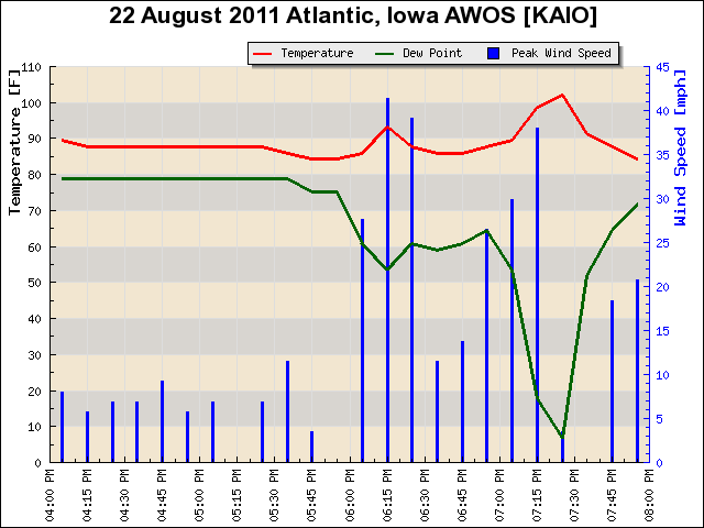
24 Aug 2011 05:33 AMRapidly decaying storms last evening over southwestern Iowa produced what appears to be a heat burst event. The featured chart is a time series from the Atlantic AWOS showing a temperature rise above 100 degrees and a dew point drop to 7 degrees, which is a classic heat burst type signature. There is some doubt if the 7 degree dew point is legitimate as other sites in the area only dropped to as much as the mid 40s. Regardless, these events typically also bring damaging winds and a few trees were reported down. Heat bursts are not fully understood by scientists yet, but the common explanation is a decaying thunderstorm encounters a layer of dry air below the storm. Virga then falls into this layer, which quickly cools it by evaporation and the air mass rapidly sinks to the ground and warms along the way.
Voting:
Good: 19
Bad: 3
Tags: heatburst 2011
Wichita Heat Burst
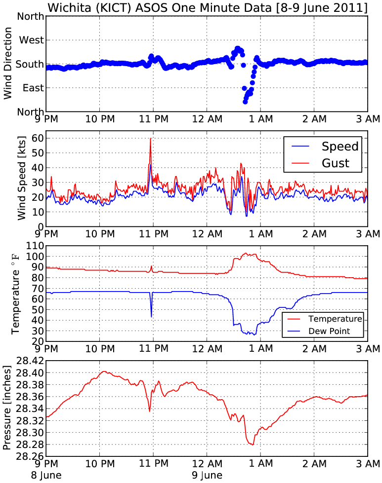
10 Jun 2011 05:55 AMEarly Thursday morning, the Wichita Kansas airport weather sensor recorded a somewhat rare meteorological phenomena known as a heat burst. These events consist of a rapid rise in temperature along with a drop in dew point. The featured chart displays the one minute interval observations from the airport sensor showing perhaps two heat burst signatures. A rise in temperature to over 100 degrees can be seen along with a drop in dew point to near 30. The physical reason for these events remains somewhat a mystery, but they are almost always found near an area of rapidly decaying rain showers.
Voting:
Good: 39
Bad: 19
Tags: heatburst
Small Heat Burst
06 Aug 2009 05:17 AMA decaying area of thunderstorms produced a small heat burst over small portions of Eastern Iowa Monday morning. The featured chart is a 1 minute time series of AWOS observations from the Monticello airport. You can see the classic coupled rise of temperature with drop of dew point with an increased wind speed. Sometimes these events can lead to very rapid warming (enough to damage some plants).
Voting:
Good: 19
Bad: 3
Tags: heatburst

Heat Burst Event
04 Aug 2008 06:38 AMThe featured time trace is taken from one of the KELO-TV WeatherNet stations in Sioux Falls on Sunday morning. The rapid and temporary rise in temperature and drop in dew point is a classic signature. These events are often caused by rapidly decaying thunderstorms producing a downward rush of air that warms as the pressure increases. This air hits the ground and spreads out over a limited area producing high winds with hot and dry conditions.
Voting:
Good: 24
Bad: 8
Tags: heatburst
View larger image
5 AM IEM plot showing the heat burst effects at the Fort Dodge ASOS (temp is 93 over 48!)
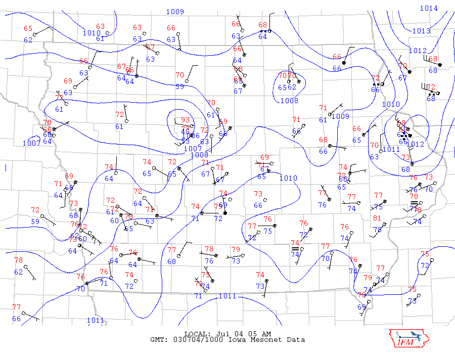
Heat Burst
04 Jul 2003 09:32 AMNorth central Iowa experienced a weather phenomena called a heat burst early this morning. Heat bursts are caused my warm and dry downdrafts from nearby thunderstorms. Many IEM sites sensed this event. Rockwell City, NW Webster, Farnhamville, and Fort Dodge.
Tags: heatburst
Wild Weather Ride!
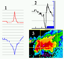
18 Apr 2002 08:10 AMA powerfull supercell [3] brought very large hail, strong winds and a brief tornado to Iowa last night. A very distinct pressure couplet [2] can be seen at Coon Rapids when this supercell pasted. Figure [1] shows evidence that a heat burst occured this morning in Iowa.
Tags: heatburst meso