Past IEM Features tagged: front

50 Degree Range
20 Feb 2018 05:27 AMYour location in the state on Monday made a for big difference with how warm it felt. The featured chart displays all Iowa ASOS/AWOS temperature reports for Sunday and Monday along with the hourly range in temperature over the state (red line). This range in temperature briefly touched 50 degrees on Monday as southeastern Iowa was well into the 60s and northwestern Iowa was in the teens! This strong contrast in temperature will make for a wintery mess on Tuesday as conditions will be favorable for freezing rain.
Voting:
Good: 10
Bad: 1
Abstain: 1
Tags: front

Waffling Front
09 Oct 2017 05:36 AMA frontal boundary was draped over Iowa Friday evening and into Saturday. The featured chart displays a time series of air temperature and wind direction reports from a weather station located on the Agronomy Hall building at ISU. It is interesting to notice how the front was waffling back and forth over the area for the evening. The sign of this movement can be seen by the change in wind direction and air temperature. The switch of the wind to the northwest brought cooler temperatures and the swing back to southeast brought warmer temperatures.
Voting:
Good: 7
Bad: 0
Tags: front

Largest 6 Hour Drops
22 Nov 2016 05:34 AMOn Friday morning, the first major cold front of the season plowed through Iowa. At the Des Moines Airport, the temperature dropped about 20 degrees between 6 AM and noon. The featured chart looks at the largest six hour temperature drops reported at the site during November. The largest drop of 35 degrees happened during the same 6 AM to noon period back in 1940! Temperatures will continue to be chilly with a cold rain on Tuesday.
Voting:
Good: 13
Bad: 0
Tags: front

Largest 24 Hour Drops
02 Dec 2014 05:40 AMThe most recent Arctic front passage over the weekend brought a dramatic change in temperatures. The featured chart displays the computed largest 24 hour temperature change based on hourly model analyses of near surface air temperature. For Iowa, the largest drop was in the 20 to 50 degree range. Much larger changes happened over the High Plains in the 50 to 70 degree range. This analysis also indicates values approaching 80 degrees over Montana! Thankfully, temperatures are back on the upswing for us with above freezing weather common for the rest of the week.
Voting:
Good: 13
Bad: 14
Abstain: 12
Tags: front

48 degrees
02 May 2013 03:40 AMMay Day felt more like Mother Nature yelling "mayday" as very cold air along with snow entered the state. The cold front still bisected the state by mid afternoon on Wednesday leaving the far eastern portions in the warm air. Temperatures soared well into the 80s while northwest Iowa was near freezing. The featured top chart displays the hourly temperature difference between Burlington and Sioux City since 1 March. The largest difference was 48 degrees with Burlington reporting 82 degrees while Sioux City was at 34. Based on IEM archives, this was the largest temperature difference between the sites on record for May. The largest difference for any month is 61 degrees on 14 Dec 2008.
Voting:
Good: 59
Bad: 9
Tags: 2013 front may

Cold Front Passage
08 Mar 2012 05:54 AMOur experience with very mild air for early March ended on Wednesday with the passage of a cold front ushering in more seasonable air. The featured chart presents a time series of air temperature for some automated weather sites in the state. Cold front passages like this create a very difficult forecasting situation as the timing of the front greatly impacts the high temperature for the day.
Voting:
Good: 25
Bad: 3
Tags: front

Almost forgot about winter
02 Mar 2011 06:00 AMThe first day of March was a very pleasant day with sunshine and temperatures in the upper 40s and 50s. One almost forgot about winter and hoped the end of meteorological winter was the end of the actual winter season as well. But then, a cold front swept the state during the evening and dropped temperatures below freezing and a brisk wind pushed wind chills to values below zero in some locations. The featured chart shows the change for Denison from a high yesterday of 57 to a wind chill of -5 this morning.
Voting:
Good: 14
Bad: 4
Tags: front

48 degree contrast
23 Nov 2010 05:55 AMA passing storm system brought very warm air into southeastern Iowa on Monday. Temperatures reached the lower 70s while the northwestern half of the state struggled in the 30s. The featured map presents the high temperature on Monday with Keokuk shown at 76 degrees and Spencer at only 28 degrees, a 48 degree difference! This very warm air helped to produce hail and tornadoes yesterday over Illinois and into Wisconsin. There will be no lucky ones in the state today with cold air in firm control.
Voting:
Good: 27
Bad: 9
Tags: front
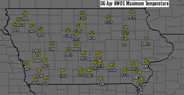
34 degrees difference
07 Apr 2010 05:10 AM34 degrees difference was the separation of high temperatures between Iowa Falls (IFA) and Newton (TNU) on Tuesday. The large gradient in temperatures was thanks to a warm front that helped to develop strong thunderstorms Tuesday evening bringing very large hail and damaging winds. After a cool day today, temperatures are expected to warm into the weekend with plenty of sunshine expected.
Voting:
Good: 41
Bad: 3
Tags: front
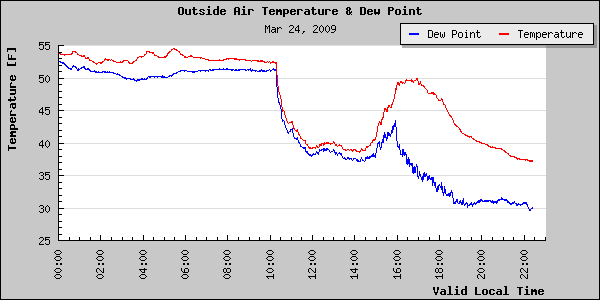
Take a bite out of the curve
25 Mar 2009 06:14 AMThe featured time series is from the weather station on top of the Agronomy Building in Ames on Tuesday. A cold front dropped temperatures mid morning, but some clearing and warmer air worked its way into the state by mid afternoon allowing temperatures to recover some before sunset. The resulting curve looks as if somebody got hungry and took a bite out of it!
Voting:
Good: 22
Bad: 6
Tags: front

60 degree drop
03 Mar 2008 06:56 AMThe featured chart is of recent air temperatures and wind chill values from the Des Moines Airport. Sunday afternoon saw an impressive push of warm air into the state with highs reaching the 50s to even 70. A strong cold front then swept the state clean of this warm air late Sunday afternoon. Wind chill temperatures are now some 60 degrees colder in a period of less than one day.
Voting:
Good: 16
Bad: 6
Tags: front

A wild weekend
03 Dec 2007 06:34 AMThe weather this past weekend was a wild ride with snow, rain, freezing rain, sleet and even thunder reported in the state. Temperatures started on Saturday below freezing with snow and sleet changing over to freezing rain and then rain. A surge of warm air rushed into the state Saturday night melting much of the frozen ice and snow, but quickly refroze by Sunday morning as very cold air was ushered in by a cold front. Temperatures then cooled off into the teens and single digits Sunday night to where we are this fine Monday morning. What a weekend!
Voting:
Good: 21
Bad: 5
Tags: front

Dry line
08 Jun 2007 07:09 AMA dry line is a term used by meteorologists to describe a boundary between moist and very dry air masses, but it differs from a cold front such that temperatures are often as warm or warmer behind the boundary. These boundaries are common in places like Texas and Oklahoma, but are sometimes brought to Iowa by powerful storm systems like the one we experienced yesterday and often also spark severe weather. The featured image is from IEM Northeast Ames sensor showing the drop in dew point with the passage of the dry line.
Voting:
Good: 23
Bad: 16
Tags: front

20 degrees in 50 miles
21 May 2007 07:05 AMA front staled out over Northeast Iowa on Sunday seperating distinct air masses for most of the day. The featured chart is a temperature comparison between Oelwien and Decorah, who are only seperated by 50 miles. Places further to the east even struggled to get out of the 40s, while most of Iowa was in the lower 80s. This boundary will lift further north today allowing places like Decorah to enjoy the 80s as well.
Voting:
Good: 22
Bad: 5
Tags: front

Dropping fast
05 Oct 2005 06:45 AMThe featured time series is from the Worthington, MN KELO WeatherNet site, which is in SW Minnesota. The long advertised cold front has been waffling around over NW Iowa for the past 2 days, but is slowing making progress SE this morning. On the plot, it appears it went through Worthington shortly after 4 AM and has dropped its temperature by 17 degrees thus far. This pattern will be common for most of the Iowa today with even colder air then working into the state later today.
Voting:
Good: 23
Bad: 11
Tags: front

30 Degrees of Difference
03 Jun 2002 07:29 AMA strong warm front was bisecting the state yesterday. Depending on which side of the front you were, your Sunday was either hot and muggy or cool and damp. The front has shifted south a bit this morning.
Tags: front

Amazing Contrast
02 Apr 2002 08:08 AMA warm front made its way into Western Iowa on Monday. This resulted in an amazing contrast in temperatures. SW Iowa warmed almost to 80°F, while NE Iowa suffered with snow showers and much cooler temperatures.
Tags: front

Location is everything
06 Mar 2002 07:32 AMA warm front lifted north into Iowa yesterday bringing much warmer temperatures for those south of the front. North of the front, temperatures were about 10 to 20 degrees cooler.
Tags: front