National Weather Service Raw Text Product
Displaying AFOS PIL: SPSSTO Product Timestamp: 2025-06-23 22:12 UTC
Previous in Time Latest Product Next in Time
View All KSTO Products for 23 Jun 2025 View All SPS Products for 23 Jun 2025 View As Image Download As Text
939
WWUS86 KSTO 232212
SPSSTO
Special Weather Statement
National Weather Service Sacramento CA
312 PM PDT Mon Jun 23 2025
CAZ069-232245-
West Slope Northern Sierra Nevada CA-
312 PM PDT Mon Jun 23 2025
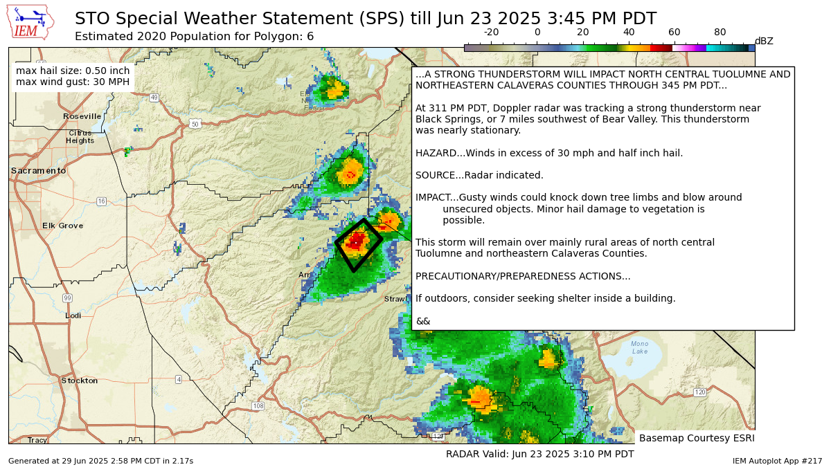
...A STRONG THUNDERSTORM WILL IMPACT NORTH CENTRAL TUOLUMNE AND
NORTHEASTERN CALAVERAS COUNTIES THROUGH 345 PM PDT...
At 311 PM PDT, Doppler radar was tracking a strong thunderstorm near
Black Springs, or 7 miles southwest of Bear Valley. This thunderstorm
was nearly stationary.
HAZARD...Winds in excess of 30 mph and half inch hail.
SOURCE...Radar indicated.
IMPACT...Gusty winds could knock down tree limbs and blow around
unsecured objects. Minor hail damage to vegetation is
possible.
This storm will remain over mainly rural areas of north central
Tuolumne and northeastern Calaveras Counties.
PRECAUTIONARY/PREPAREDNESS ACTIONS...
If outdoors, consider seeking shelter inside a building.
&&
LAT...LON 3844 12009 3838 12002 3828 12013 3837 12020
TIME...MOT...LOC 2211Z 049DEG 2KT 3838 12011
MAX HAIL SIZE...0.50 IN
MAX WIND GUST...30 MPH
$$
Forrest
Autoplot 217 generated the following image below. You may find more customization options , like removal of RADAR, for this image by visiting that autoplot.
