National Weather Service Raw Text Product
Displaying AFOS PIL: SPSSTO Product Timestamp: 2025-06-23 21:54 UTC
Previous in Time Latest Product Next in Time
View All KSTO Products for 23 Jun 2025 View All SPS Products for 23 Jun 2025 View As Image Download As Text
655
WWUS86 KSTO 232154
SPSSTO
Special Weather Statement
National Weather Service Sacramento CA
254 PM PDT Mon Jun 23 2025
CAZ069-232230-
West Slope Northern Sierra Nevada CA-
254 PM PDT Mon Jun 23 2025
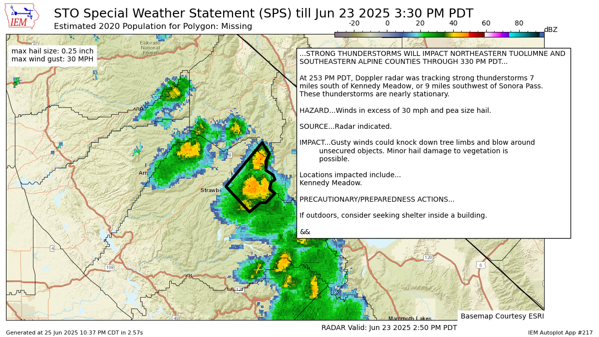
...STRONG THUNDERSTORMS WILL IMPACT NORTHEASTERN TUOLUMNE AND
SOUTHEASTERN ALPINE COUNTIES THROUGH 330 PM PDT...
At 253 PM PDT, Doppler radar was tracking strong thunderstorms 7
miles south of Kennedy Meadow, or 9 miles southwest of Sonora Pass.
These thunderstorms are nearly stationary.
HAZARD...Winds in excess of 30 mph and pea size hail.
SOURCE...Radar indicated.
IMPACT...Gusty winds could knock down tree limbs and blow around
unsecured objects. Minor hail damage to vegetation is
possible.
Locations impacted include...
Kennedy Meadow.
PRECAUTIONARY/PREPAREDNESS ACTIONS...
If outdoors, consider seeking shelter inside a building.
&&
LAT...LON 3814 11965 3814 11968 3810 11974 3821 11987
3840 11967 3835 11963 3832 11965 3828 11965
3826 11961 3824 11960 3823 11962 3820 11963
3818 11960
TIME...MOT...LOC 2153Z 050DEG 3KT 3821 11973
MAX HAIL SIZE...0.25 IN
MAX WIND GUST...30 MPH
$$
Forrest
Autoplot 217 generated the following image below. You may find more customization options , like removal of RADAR, for this image by visiting that autoplot.
