National Weather Service Raw Text Product
Displaying AFOS PIL: PNSLSX Received: 2019-05-25 15:52 UTC
Previous in Time Latest Product Next in Time
View All KLSX Products for 25 May 2019 View All PNS Products for 25 May 2019 View As Image Download As Text
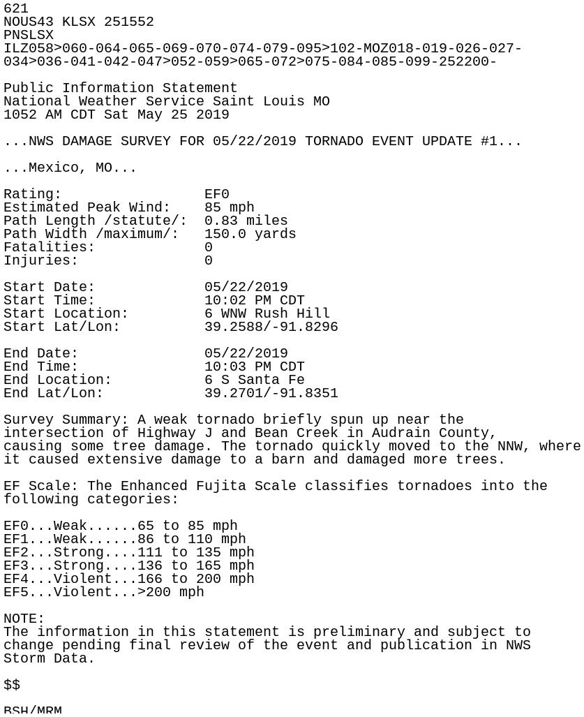
621
NOUS43 KLSX 251552
PNSLSX
ILZ058>060-064-065-069-070-074-079-095>102-MOZ018-019-026-027-
034>036-041-042-047>052-059>065-072>075-084-085-099-252200-

Public Information Statement
National Weather Service Saint Louis MO
1052 AM CDT Sat May 25 2019

...NWS DAMAGE SURVEY FOR 05/22/2019 TORNADO EVENT UPDATE #1...

...Mexico, MO...

Rating:                 EF0
Estimated Peak Wind:    85 mph
Path Length /statute/:  0.83 miles
Path Width /maximum/:   150.0 yards
Fatalities:             0
Injuries:               0

Start Date:             05/22/2019
Start Time:             10:02 PM CDT
Start Location:         6 WNW Rush Hill
Start Lat/Lon:          39.2588/-91.8296

End Date:               05/22/2019
End Time:               10:03 PM CDT
End Location:           6 S Santa Fe
End Lat/Lon:            39.2701/-91.8351

Survey Summary: A weak tornado briefly spun up near the
intersection of Highway J and Bean Creek in Audrain County,
causing some tree damage. The tornado quickly moved to the NNW, where
it caused extensive damage to a barn and damaged more trees.

EF Scale: The Enhanced Fujita Scale classifies tornadoes into the
following categories:

EF0...Weak......65 to 85 mph
EF1...Weak......86 to 110 mph
EF2...Strong....111 to 135 mph
EF3...Strong....136 to 165 mph
EF4...Violent...166 to 200 mph
EF5...Violent...>200 mph

NOTE:
The information in this statement is preliminary and subject to
change pending final review of the event and publication in NWS
Storm Data.

$$

BSH/MRM