National Weather Service Raw Text Product
Displaying AFOS PIL: PNSLOT Received: 2020-03-29 21:22 UTC
Previous in Time Latest Product Next in Time
View All KLOT Products for 29 Mar 2020 View All PNS Products for 29 Mar 2020 View As Image Download As Text
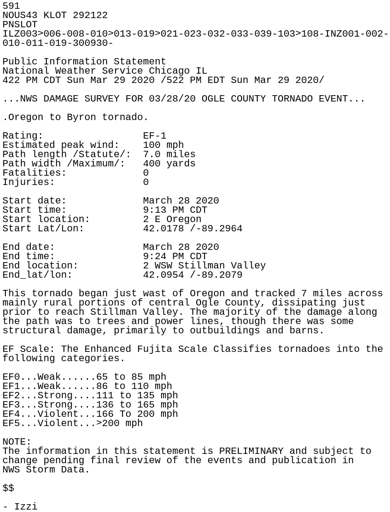
591
NOUS43 KLOT 292122
PNSLOT
ILZ003>006-008-010>013-019>021-023-032-033-039-103>108-INZ001-002-
010-011-019-300930-

Public Information Statement
National Weather Service Chicago IL
422 PM CDT Sun Mar 29 2020 /522 PM EDT Sun Mar 29 2020/

...NWS DAMAGE SURVEY FOR 03/28/20 OGLE COUNTY TORNADO EVENT...

.Oregon to Byron tornado.

Rating:                 EF-1
Estimated peak wind:    100 mph
Path length /Statute/:  7.0 miles
Path width /Maximum/:   400 yards
Fatalities:             0
Injuries:               0

Start date:             March 28 2020
Start time:             9:13 PM CDT
Start location:         2 E Oregon
Start Lat/Lon:          42.0178 /-89.2964

End date:               March 28 2020
End time:               9:24 PM CDT
End location:           2 WSW Stillman Valley
End_lat/lon:            42.0954 /-89.2079

This tornado began just wast of Oregon and tracked 7 miles across
mainly rural portions of central Ogle County, dissipating just
prior to reach Stillman Valley. The majority of the damage along
the path was to trees and power lines, though there was some
structural damage, primarily to outbuildings and barns.

EF Scale: The Enhanced Fujita Scale Classifies tornadoes into the
following categories.

EF0...Weak......65 to 85 mph
EF1...Weak......86 to 110 mph
EF2...Strong....111 to 135 mph
EF3...Strong....136 to 165 mph
EF4...Violent...166 To 200 mph
EF5...Violent...>200 mph

NOTE:
The information in this statement is PRELIMINARY and subject to
change pending final review of the events and publication in
NWS Storm Data.

$$

- Izzi