National Weather Service Raw Text Product
Displaying AFOS PIL: PNSJAX Received: 2020-04-24 21:12 UTC
Previous in Time Latest Product Next in Time
View All KJAX Products for 24 Apr 2020 View All PNS Products for 24 Apr 2020 View As Image Download As Text
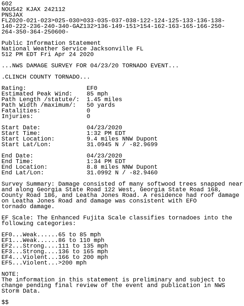
602
NOUS42 KJAX 242112
PNSJAX
FLZ020-021-023>025-030>033-035-037-038-122-124-125-133-136-138-
140-222-236-240-340-GAZ132>136-149-151>154-162-163-165-166-250-
264-350-364-250600-

Public Information Statement
National Weather Service Jacksonville FL
512 PM EDT Fri Apr 24 2020

...NWS DAMAGE SURVEY FOR 04/23/20 TORNADO EVENT...

.CLINCH COUNTY TORNADO...

Rating:                 EF0
Estimated Peak Wind:    85 mph
Path Length /statute/:  1.45 miles
Path Width /maximum/:   50 yards
Fatalities:             0
Injuries:               0

Start Date:             04/23/2020
Start Time:             1:32 PM EDT
Start Location:         9.4 miles NNW Dupont
Start Lat/Lon:          31.0945 N / -82.9699

End Date:               04/23/2020
End Time:               1:34 PM EDT
End Location:           8.8 miles NNW Dupont
End Lat/Lon:            31.0992 N / -82.9460

Survey Summary: Damage consisted of many softwood trees snapped near
and along Georgia State Road 122 West, Georgia State Road 168,
County Road 186, and Leatha Jones Road. A residence had roof damage
on Leatha Jones Road and damage was consistent with EFO
tornado damage.

EF Scale: The Enhanced Fujita Scale classifies tornadoes into the
following categories:

EF0...Weak......65 to 85 mph
EF1...Weak......86 to 110 mph
EF2...Strong....111 to 135 mph
EF3...Strong....136 to 165 mph
EF4...Violent...166 to 200 mph
EF5...Violent...>200 mph

NOTE:
The information in this statement is preliminary and subject to
change pending final review of the event and publication in NWS
Storm Data.

$$