National Weather Service Raw Text Product
Displaying AFOS PIL: HYDILM Received: 2021-06-29 12:48 UTC
Previous in Time Latest Product Next in Time
View All KILM Products for 29 Jun 2021 View All HYD Products for 29 Jun 2021 View As Image Download As Text
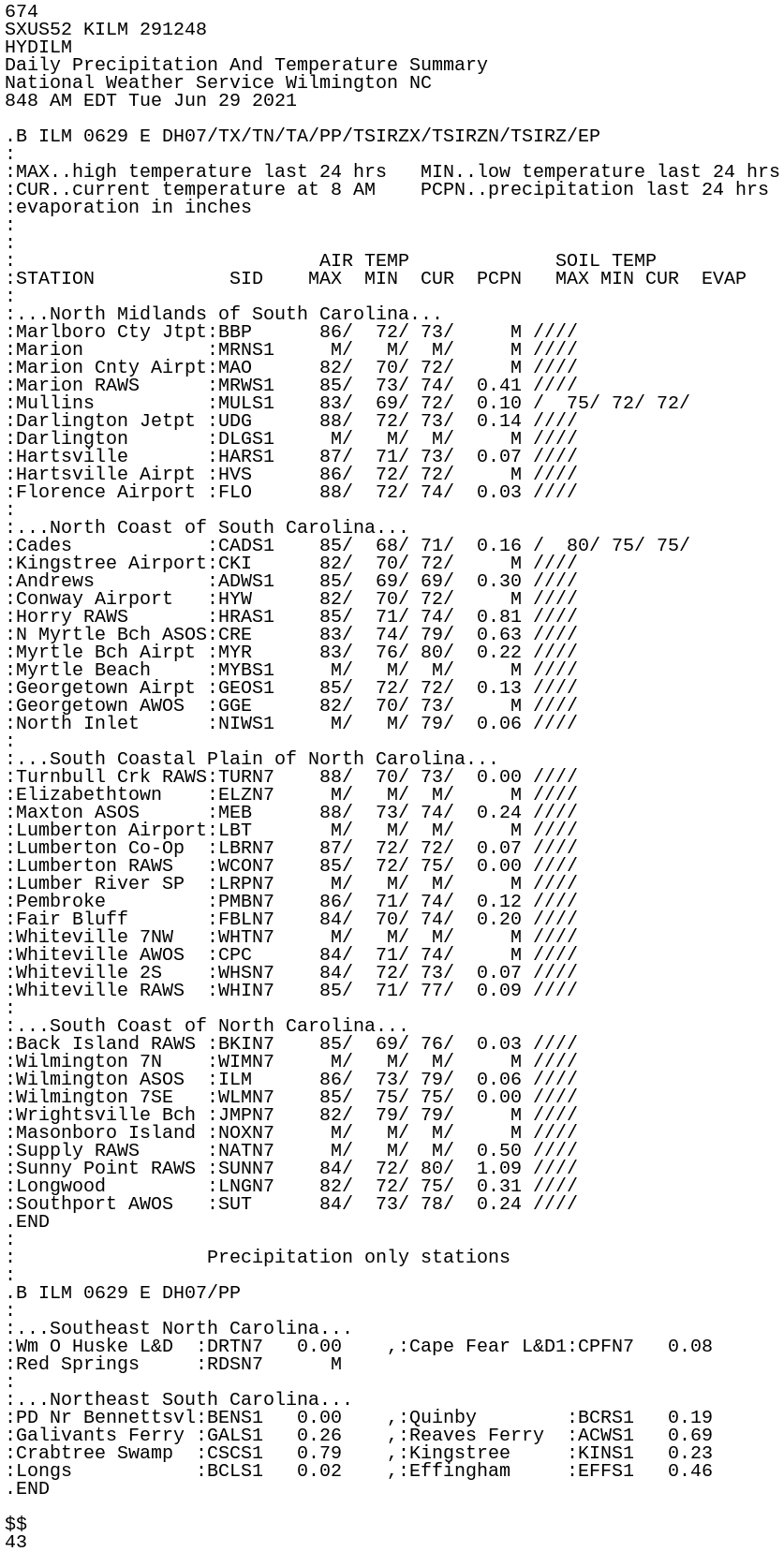
674
SXUS52 KILM 291248
HYDILM
Daily Precipitation And Temperature Summary
National Weather Service Wilmington NC
848 AM EDT Tue Jun 29 2021

.B ILM 0629 E DH07/TX/TN/TA/PP/TSIRZX/TSIRZN/TSIRZ/EP
:
:MAX..high temperature last 24 hrs   MIN..low temperature last 24 hrs
:CUR..current temperature at 8 AM    PCPN..precipitation last 24 hrs
:evaporation in inches
:
:
:                           AIR TEMP             SOIL TEMP
:STATION            SID    MAX  MIN  CUR  PCPN   MAX MIN CUR  EVAP
:
:...North Midlands of South Carolina...
:Marlboro Cty Jtpt:BBP      86/  72/ 73/     M ////
:Marion           :MRNS1     M/   M/  M/     M ////
:Marion Cnty Airpt:MAO      82/  70/ 72/     M ////
:Marion RAWS      :MRWS1    85/  73/ 74/  0.41 ////
:Mullins          :MULS1    83/  69/ 72/  0.10 /  75/ 72/ 72/
:Darlington Jetpt :UDG      88/  72/ 73/  0.14 ////
:Darlington       :DLGS1     M/   M/  M/     M ////
:Hartsville       :HARS1    87/  71/ 73/  0.07 ////
:Hartsville Airpt :HVS      86/  72/ 72/     M ////
:Florence Airport :FLO      88/  72/ 74/  0.03 ////
:
:...North Coast of South Carolina...
:Cades            :CADS1    85/  68/ 71/  0.16 /  80/ 75/ 75/
:Kingstree Airport:CKI      82/  70/ 72/     M ////
:Andrews          :ADWS1    85/  69/ 69/  0.30 ////
:Conway Airport   :HYW      82/  70/ 72/     M ////
:Horry RAWS       :HRAS1    85/  71/ 74/  0.81 ////
:N Myrtle Bch ASOS:CRE      83/  74/ 79/  0.63 ////
:Myrtle Bch Airpt :MYR      83/  76/ 80/  0.22 ////
:Myrtle Beach     :MYBS1     M/   M/  M/     M ////
:Georgetown Airpt :GEOS1    85/  72/ 72/  0.13 ////
:Georgetown AWOS  :GGE      82/  70/ 73/     M ////
:North Inlet      :NIWS1     M/   M/ 79/  0.06 ////
:
:...South Coastal Plain of North Carolina...
:Turnbull Crk RAWS:TURN7    88/  70/ 73/  0.00 ////
:Elizabethtown    :ELZN7     M/   M/  M/     M ////
:Maxton ASOS      :MEB      88/  73/ 74/  0.24 ////
:Lumberton Airport:LBT       M/   M/  M/     M ////
:Lumberton Co-Op  :LBRN7    87/  72/ 72/  0.07 ////
:Lumberton RAWS   :WCON7    85/  72/ 75/  0.00 ////
:Lumber River SP  :LRPN7     M/   M/  M/     M ////
:Pembroke         :PMBN7    86/  71/ 74/  0.12 ////
:Fair Bluff       :FBLN7    84/  70/ 74/  0.20 ////
:Whiteville 7NW   :WHTN7     M/   M/  M/     M ////
:Whiteville AWOS  :CPC      84/  71/ 74/     M ////
:Whiteville 2S    :WHSN7    84/  72/ 73/  0.07 ////
:Whiteville RAWS  :WHIN7    85/  71/ 77/  0.09 ////
:
:...South Coast of North Carolina...
:Back Island RAWS :BKIN7    85/  69/ 76/  0.03 ////
:Wilmington 7N    :WIMN7     M/   M/  M/     M ////
:Wilmington ASOS  :ILM      86/  73/ 79/  0.06 ////
:Wilmington 7SE   :WLMN7    85/  75/ 75/  0.00 ////
:Wrightsville Bch :JMPN7    82/  79/ 79/     M ////
:Masonboro Island :NOXN7     M/   M/  M/     M ////
:Supply RAWS      :NATN7     M/   M/  M/  0.50 ////
:Sunny Point RAWS :SUNN7    84/  72/ 80/  1.09 ////
:Longwood         :LNGN7    82/  72/ 75/  0.31 ////
:Southport AWOS   :SUT      84/  73/ 78/  0.24 ////
.END
:
:                 Precipitation only stations
:
.B ILM 0629 E DH07/PP
:
:...Southeast North Carolina...
:Wm O Huske L&D  :DRTN7   0.00    ,:Cape Fear L&D1:CPFN7   0.08
:Red Springs     :RDSN7      M
:
:...Northeast South Carolina...
:PD Nr Bennettsvl:BENS1   0.00    ,:Quinby        :BCRS1   0.19
:Galivants Ferry :GALS1   0.26    ,:Reaves Ferry  :ACWS1   0.69
:Crabtree Swamp  :CSCS1   0.79    ,:Kingstree     :KINS1   0.23
:Longs           :BCLS1   0.02    ,:Effingham     :EFFS1   0.46
.END

$$
43