National Weather Service Raw Text Product
Displaying AFOS PIL: PNSPAH Received: 2018-09-10 19:15 UTC
Previous in Time Latest Product Next in Time
View All KPAH Products for 10 Sep 2018 View All PNS Products for 10 Sep 2018 View As Image Download As Text
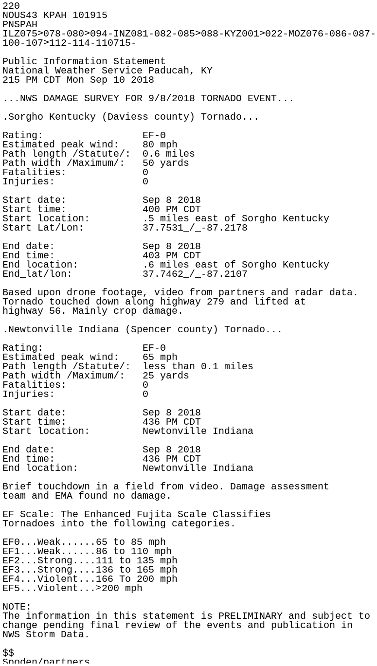
220
NOUS43 KPAH 101915
PNSPAH
ILZ075>078-080>094-INZ081-082-085>088-KYZ001>022-MOZ076-086-087-
100-107>112-114-110715-

Public Information Statement
National Weather Service Paducah, KY
215 PM CDT Mon Sep 10 2018

...NWS DAMAGE SURVEY FOR 9/8/2018 TORNADO EVENT...

.Sorgho Kentucky (Daviess county) Tornado...

Rating:                 EF-0
Estimated peak wind:    80 mph
Path length /Statute/:  0.6 miles
Path width /Maximum/:   50 yards
Fatalities:             0
Injuries:               0

Start date:             Sep 8 2018
Start time:             400 PM CDT
Start location:         .5 miles east of Sorgho Kentucky
Start Lat/Lon:          37.7531_/_-87.2178

End date:               Sep 8 2018
End time:               403 PM CDT
End location:           .6 miles east of Sorgho Kentucky
End_lat/lon:            37.7462_/_-87.2107

Based upon drone footage, video from partners and radar data.
Tornado touched down along highway 279 and lifted at
highway 56. Mainly crop damage.

.Newtonville Indiana (Spencer county) Tornado...

Rating:                 EF-0
Estimated peak wind:    65 mph
Path length /Statute/:  less than 0.1 miles
Path width /Maximum/:   25 yards
Fatalities:             0
Injuries:               0

Start date:             Sep 8 2018
Start time:             436 PM CDT
Start location:         Newtonville Indiana

End date:               Sep 8 2018
End time:               436 PM CDT
End location:           Newtonville Indiana

Brief touchdown in a field from video. Damage assessment
team and EMA found no damage.

EF Scale: The Enhanced Fujita Scale Classifies
Tornadoes into the following categories.

EF0...Weak......65 to 85 mph
EF1...Weak......86 to 110 mph
EF2...Strong....111 to 135 mph
EF3...Strong....136 to 165 mph
EF4...Violent...166 To 200 mph
EF5...Violent...>200 mph

NOTE:
The information in this statement is PRELIMINARY and subject to
change pending final review of the events and publication in
NWS Storm Data.

$$
Spoden/partners