National Weather Service Raw Text Product
Displaying AFOS PIL: PNSFWD Received: 2018-02-20 07:04 UTC
Previous in Time Latest Product Next in Time
View All KFWD Products for 20 Feb 2018 View All PNS Products for 20 Feb 2018 View As Image Download As Text
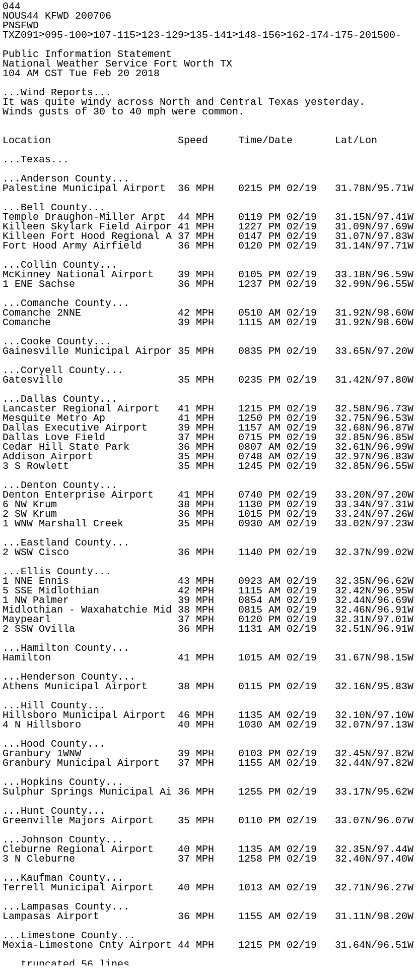
044
NOUS44 KFWD 200706
PNSFWD
TXZ091>095-100>107-115>123-129>135-141>148-156>162-174-175-201500-

Public Information Statement
National Weather Service Fort Worth TX
104 AM CST Tue Feb 20 2018

...Wind Reports...
It was quite windy across North and Central Texas yesterday.
Winds gusts of 30 to 40 mph were common.


Location                     Speed     Time/Date       Lat/Lon

...Texas...

...Anderson County...
Palestine Municipal Airport  36 MPH    0215 PM 02/19   31.78N/95.71W

...Bell County...
Temple Draughon-Miller Arpt  44 MPH    0119 PM 02/19   31.15N/97.41W
Killeen Skylark Field Airpor 41 MPH    1227 PM 02/19   31.09N/97.69W
Killeen Fort Hood Regional A 37 MPH    0147 PM 02/19   31.07N/97.83W
Fort Hood Army Airfield      36 MPH    0120 PM 02/19   31.14N/97.71W

...Collin County...
McKinney National Airport    39 MPH    0105 PM 02/19   33.18N/96.59W
1 ENE Sachse                 36 MPH    1237 PM 02/19   32.99N/96.55W

...Comanche County...
Comanche 2NNE                42 MPH    0510 AM 02/19   31.92N/98.60W
Comanche                     39 MPH    1115 AM 02/19   31.92N/98.60W

...Cooke County...
Gainesville Municipal Airpor 35 MPH    0835 PM 02/19   33.65N/97.20W

...Coryell County...
Gatesville                   35 MPH    0235 PM 02/19   31.42N/97.80W

...Dallas County...
Lancaster Regional Airport   41 MPH    1215 PM 02/19   32.58N/96.73W
Mesquite Metro Ap            41 MPH    1250 PM 02/19   32.75N/96.53W
Dallas Executive Airport     39 MPH    1157 AM 02/19   32.68N/96.87W
Dallas Love Field            37 MPH    0715 PM 02/19   32.85N/96.85W
Cedar Hill State Park        36 MPH    0807 AM 02/19   32.61N/96.99W
Addison Airport              35 MPH    0748 AM 02/19   32.97N/96.83W
3 S Rowlett                  35 MPH    1245 PM 02/19   32.85N/96.55W

...Denton County...
Denton Enterprise Airport    41 MPH    0740 PM 02/19   33.20N/97.20W
6 NW Krum                    38 MPH    1130 PM 02/19   33.34N/97.31W
2 SW Krum                    36 MPH    1015 PM 02/19   33.24N/97.26W
1 WNW Marshall Creek         35 MPH    0930 AM 02/19   33.02N/97.23W

...Eastland County...
2 WSW Cisco                  36 MPH    1140 PM 02/19   32.37N/99.02W

...Ellis County...
1 NNE Ennis                  43 MPH    0923 AM 02/19   32.35N/96.62W
5 SSE Midlothian             42 MPH    1115 AM 02/19   32.42N/96.95W
1 NW Palmer                  39 MPH    0854 AM 02/19   32.44N/96.69W
Midlothian - Waxahatchie Mid 38 MPH    0815 AM 02/19   32.46N/96.91W
Maypearl                     37 MPH    0120 PM 02/19   32.31N/97.01W
2 SSW Ovilla                 36 MPH    1131 AM 02/19   32.51N/96.91W

...Hamilton County...
Hamilton                     41 MPH    1015 AM 02/19   31.67N/98.15W

...Henderson County...
Athens Municipal Airport     38 MPH    0115 PM 02/19   32.16N/95.83W

...Hill County...
Hillsboro Municipal Airport  46 MPH    1135 AM 02/19   32.10N/97.10W
4 N Hillsboro                40 MPH    1030 AM 02/19   32.07N/97.13W

...Hood County...
Granbury 1WNW                39 MPH    0103 PM 02/19   32.45N/97.82W
Granbury Municipal Airport   37 MPH    1155 AM 02/19   32.44N/97.82W

...Hopkins County...
Sulphur Springs Municipal Ai 36 MPH    1255 PM 02/19   33.17N/95.62W

...Hunt County...
Greenville Majors Airport    35 MPH    0110 PM 02/19   33.07N/96.07W

...Johnson County...
Cleburne Regional Airport    40 MPH    1135 AM 02/19   32.35N/97.44W
3 N Cleburne                 37 MPH    1258 PM 02/19   32.40N/97.40W

...Kaufman County...
Terrell Municipal Airport    40 MPH    1013 AM 02/19   32.71N/96.27W

...Lampasas County...
Lampasas Airport             36 MPH    1155 AM 02/19   31.11N/98.20W

...Limestone County...
Mexia-Limestone Cnty Airport 44 MPH    1215 PM 02/19   31.64N/96.51W

...McLennan County...
McGregor Executive Airport   43 MPH    0256 PM 02/19   31.48N/97.32W
McGregor 4S                  41 MPH    1201 PM 02/19   31.38N/97.41W
Waco Regional Airport        40 MPH    0957 AM 02/19   31.61N/97.23W
2 WSW Mcgregor               39 MPH    0224 PM 02/19   31.43N/97.41W

...Milam County...
Cameron Municipal Airpark    40 MPH    1255 PM 02/19   30.88N/96.97W

...Montague County...
Bowie Municipal Airport      38 MPH    1035 AM 02/19   33.60N/97.78W

...Navarro County...
Corsicana - C David Campbell 41 MPH    0516 PM 02/19   32.03N/96.40W

...Parker County...
Mineral Wells Airport        35 MPH    1125 PM 02/19   32.78N/98.06W

...Robertson County...
Hearne Municipal Airport     36 MPH    1255 PM 02/19   30.87N/96.62W
Seale 1SSE                   35 MPH    0410 PM 02/19   31.30N/96.37W

...Rockwall County...
Rockwall Municipal Airport   39 MPH    1215 PM 02/19   32.93N/96.44W

...Stephens County...
Breckenridge                 35 MPH    1155 PM 02/19   32.72N/98.89W

...Tarrant County...
Dallas/Ft. Worth Intl Arpt   45 MPH    1246 PM 02/19   32.90N/97.04W
Fort Worth Meacham Airport   44 MPH    0608 PM 02/19   32.82N/97.36W
Arlington Municipal Airport  44 MPH    1148 AM 02/19   32.66N/97.09W
Fort Worth Spinks Airport    40 MPH    1250 PM 02/19   32.56N/97.31W
Fort Worth Alliance Arpt     39 MPH    0901 AM 02/19   32.99N/97.32W
Fort Worth NAS JRB           38 MPH    0106 PM 02/19   32.77N/97.43W
3 WSW Crowley                38 MPH    1135 AM 02/19   32.56N/97.41W
1 ENE Pantego                37 MPH    1256 PM 02/19   32.72N/97.14W
2 E Pecan Acres              35 MPH    1251 PM 02/19   32.97N/97.44W
1 WSW Benbrook               35 MPH    1155 AM 02/19   32.67N/97.48W
1 NE Watauga                 35 MPH    0254 PM 02/19   32.89N/97.24W
Grand Prairie Municipal Airp 35 MPH    1250 PM 02/19   32.70N/97.05W

...Van Zandt County...
6 W Mineola                  35 MPH    0115 PM 02/19   32.67N/95.60W

...Wise County...
3 NE Rhome                   38 MPH    1228 AM 02/20   33.08N/97.42W
LBJ Grasslands               35 MPH    1102 PM 02/19   33.28N/97.63W
Decatur Municipal Airport    35 MPH    1035 AM 02/19   33.25N/97.58W

Observations are collected from a variety of sources with varying
equipment and exposures. We thank all volunteer weather observers
for their dedication. Not all data listed are considered official.

$$