National Weather Service Raw Text Product
Displaying AFOS PIL: HWOFWD Received: 2019-07-16 07:42 UTC
Previous in Time Latest Product Next in Time
View All KFWD Products for 16 Jul 2019 View All HWO Products for 16 Jul 2019 View As Image Download As Text
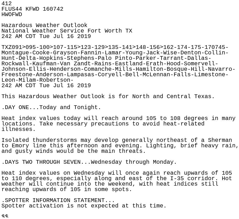
412
FLUS44 KFWD 160742
HWOFWD

Hazardous Weather Outlook
National Weather Service Fort Worth TX
242 AM CDT Tue Jul 16 2019

TXZ091>095-100>107-115>123-129>135-141>148-156>162-174-175-170745-
Montague-Cooke-Grayson-Fannin-Lamar-Young-Jack-Wise-Denton-Collin-
Hunt-Delta-Hopkins-Stephens-Palo Pinto-Parker-Tarrant-Dallas-
Rockwall-Kaufman-Van Zandt-Rains-Eastland-Erath-Hood-Somervell-
Johnson-Ellis-Henderson-Comanche-Mills-Hamilton-Bosque-Hill-Navarro-
Freestone-Anderson-Lampasas-Coryell-Bell-McLennan-Falls-Limestone-
Leon-Milam-Robertson-
242 AM CDT Tue Jul 16 2019

This Hazardous Weather Outlook is for North and Central Texas.

.DAY ONE...Today and Tonight.

Heat index values today will reach around 105 to 108 degrees in many
locations. Take necessary precautions to avoid heat-related
illnesses.

Isolated thunderstorms may develop generally northeast of a Sherman
to Emory line this afternoon and evening. Lighting, brief heavy rain,
and gusty winds would be the main threats.

.DAYS TWO THROUGH SEVEN...Wednesday through Monday.

Heat index values on Wednesday will once again reach upwards of 105
to 110 degrees, especially along and east of the I-35 corridor. Hot
weather will continue into the weekend, with heat indices still
reaching upwards of 105 in some spots.

.SPOTTER INFORMATION STATEMENT...
Spotter activation is not expected at this time.

$$