Past Features
This page lists out the IEM Daily Features for a month at a time. Features have been posted on most days since February 2002. List all feature titles.
Wed Aug 01, 2018

Dry July for Des Moines
01 Aug 2018 05:37 AM
The epic flash flooding to end June has been followed by one of the driest July's on record for Des Moines. The featured chart displays yearly July precipitation totals. 2018's total of just 0.38 inches is the driest since 1975 and the fifth driest on record. The recent dryness has been tempered somewhat by cool overnight lows and lack of excessive daytime heat. This situation looks to change as August progresses and forecasted warmer weather returns to the state.
Voting: Good - 8 Bad - 0
Tags: jul18
Generate This Chart on Website
Thu Aug 02, 2018
Highs of 90+ in August
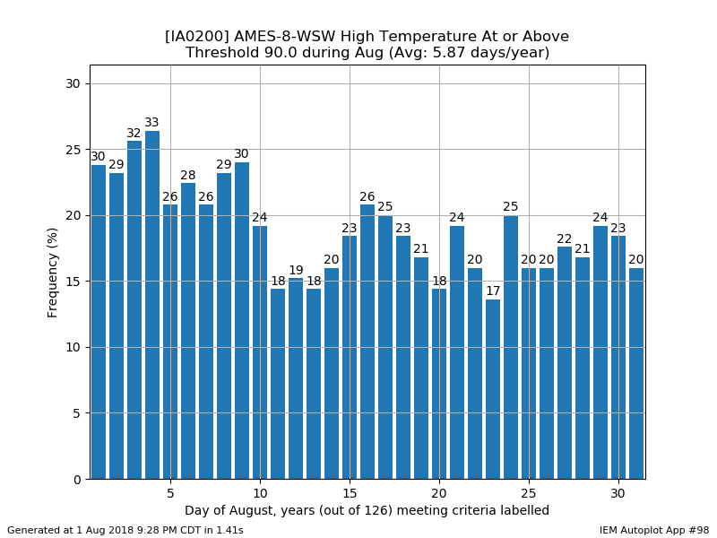
02 Aug 2018 05:34 AM
Having the calendar now say August always brings some optimism about the fast approaching fall season, but there is still plenty of time for summer during the month. The featured chart displays the daily frequencies of the high temperature being at or above 90 for Ames during August. The values labelled on the bars are the number of previous years meeting the criterion. While there is some downward slope to this chart, the magnitude is not significant meaning that each day has about the same chance of reaching 90. The forecast currently has a few days approaching 90 during the coming seven days.
Voting: Good - 8 Bad - 0
Generate This Chart on Website
Fri Aug 03, 2018

Next Seven Days
03 Aug 2018 05:34 AM
The weekly update to the US Drought Monitor was released on Thursday and showed a continued degradation over southern Iowa. For agricultural crops that are still holding on for some needed rain this growing season, time is running out. The featured map depicts the combination of the most recent Drought Monitor and the seven day forecasted precipitation amount from the Weather Prediction Center. The heaviest totals are inconveniently predicted to the north of the driest area over the state. A silver lining here is that the map is not full of zero precipitation predictions, but hotter temperatures are expected which will increase the stress on already stressed crops in the area.
Voting: Good - 16 Bad - 0
Tags: wpc usdm
Generate This Chart on Website
Mon Aug 06, 2018

Latest Date for High
06 Aug 2018 05:36 AM
For areas over southern Iowa that missed out on the rain during Sunday, temperatures were very toasty well into the 90s. Lamoni hit 98 degrees. The featured chart looks at the latest date into a year that a given high temperature was reached. Certainly this warm of weather during early August is not that exceptional. The chart shows the site hitting 98 degrees into the end of September! Highs on Monday are expected to be plenty warm over southern Iowa again.
Voting: Good - 9 Bad - 0
Generate This Chart on Website
Tue Aug 07, 2018

Big August Rainfall
07 Aug 2018 05:39 AM
Heavy rains have come to Iowa over the past few days. The featured chart displays MRMS rainfall estimates since Saturday until about 5 AM this Tuesday. The most recent US Drought Monitor is overlain as well. The first round of heavy rainfall completely missed the driest parts of the state, but some rainfall Monday and now on Tuesday has fallen over the driest locations. There was some optimism that more rain would have fallen by now over southern Iowa with this event. Sadly for the area, the near term forecast looks dry. This map will be updated later today once the rain event ends.
Voting: Good - 8 Bad - 1
Generate This Chart on Website
Wed Aug 08, 2018

Settings records by year
08 Aug 2018 05:35 AM
Waterloo set a daily record precipitation total on Monday with 1.81 inches reported. This beat the previous record of 1.08 inches set back in 2007. The featured chart looks the number of daily records set each year for the site. The totals shown are counted as time progresses and not the present day totaling of which year holds the current daily records. The black line on the chart is a simple model denoting 365/n, where n is the sequential year number. For example, in 1893 there was no daily records so each day set a record! Then the next year, one would expect to set records on roughly half of the days (365/2). The title on each plot shows the long term average number of records set per year. Interestingly, the values for daily high and precipitation are close together with the low temperature number lagging by about 10%. Will likely look more into this difference in upcoming daily features.
Voting: Good - 8 Bad - 0
Generate This Chart on Website
Thu Aug 09, 2018

Mostly on Warm Side
09 Aug 2018 05:33 AM
The featured chart shows a weekly progression of trailing 14 day normalized temperature and precipitation departures for Des Moines. The arrows indicate movement from one week to the next with the labelled day showing when the trailing 14 day departure is valid for. The chart is shown for data this year since the end of April. Please recall how cold and snowy it was in April this year. Since that time and only up until recently, temperature departures have been on the warm side of average and precipitation departures have been both wet and dry. Our current weather is trending toward the dry and hot side of this chart, so our brief period below average on temperatures will end with the next update of this plot.
Voting: Good - 7 Bad - 0
Generate This Chart on Website
Fri Aug 10, 2018

Ottumwa Multi-Year Drought
10 Aug 2018 05:34 AM
Based on long term climate sites tracked by the IEM, the driest location in the state over the past two years is Ottumwa (located southeast of Des Moines). The featured chart presents Ottumwa's trailing day precipitation departures over the past two years and the analyzed US Drought Monitor condition for the location. The precipitation departures are plotted for a trailing 91, 365, and 720 day window. The green line shows the accumulated departure over the past two years standing now at 20 inches. The brief stint at D3 classification last year shows up nicely and the rapid improvement with the big rains late last growing season. The same scenario has yet to materialize for the area this year and there is little rain in the forecast for the next seven days.
Voting: Good - 12 Bad - 1
Generate This Chart on Website
Mon Aug 13, 2018

August besting July
13 Aug 2018 05:35 AM
For Ames, there is currently about a 50% chance that this August will have a warmer average temperature than the last month of July. The featured chart looks into how common it is for one month to have a warmer average temperature than another for the same calendar year. This situation has happened for 30 years in the past, so it is certainly not a rare occurrence. The current near term forecast continues the warm for August temperatures with highs and lows both slightly above average.
Voting: Good - 7 Bad - 1
Generate This Chart on Website
Tue Aug 14, 2018

Days to accumulate Two Inches
14 Aug 2018 05:36 AM
Based on MRMS precipitation estimates, the featured map depicts the number of days one needs to go back in time before accumulating at least two inches of rainfall. This analysis is evaluated for each of the pixels in the gridded product. Two dry areas in the state stick out on this plot, most of southwestern Iowa and parts of far southeastern Iowa. The dark brown areas indicate between 50 and 60 days! The current forecast has some optimism for rainfall over southern Iowa, so hopefully it pans out!
Voting: Good - 12 Bad - 0
Generate This Chart on Website
Wed Aug 15, 2018
Play in the Rain
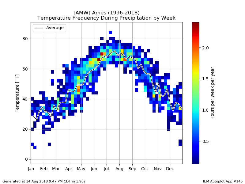
15 Aug 2018 05:36 AM
In the absence of lightning, summer rains can be nice to play in. One of the main reasons this activity is pleasant is that air temperatures are typically warm. The featured chart looks at the frequency of reported air temperatures for Ames by week of the year when precipitation is being reported. A simple weekly average is plotted as well and shows the months of July and August having the warmest temperatures during rainfall. The chart quickly plummets during the fall season, so the chilly rains are not that far away!
Voting: Good - 7 Bad - 2
Generate This Chart on Website
Thu Aug 16, 2018
Drought Monitor Weekly Changes
16 Aug 2018 05:36 AM
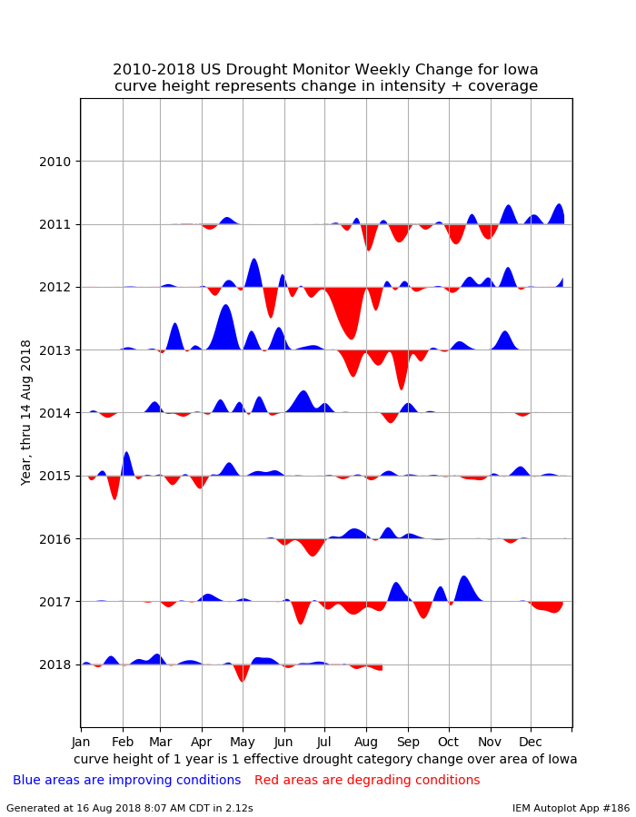
This week's US Drought Monitor will be released later this Thursday morning and should show continued degradation of the drought situation over Iowa. The featured chart attempts to illustrate the magnitude of the week to week changes in the Drought Monitor depiction over the state. The weekly data is smoothed to give a more visually appeasing appearance. The magnitude of the weekly changes is expressed in units of net one category change in the depiction over an area of the state. Putting those difficult units aside, the relative size shows the larger and smaller changes in the depiction. Of note in the plot is the year 2010, which was a flood year and had no drought analyzed over Iowa. For this year, the changes have been rather muted as the most intense portion of the drought has been confined over far southern Iowa. The lack of recent rains over most of the state now has analyzed drought creeping further north. The chart also nicely shows when the improvements showed up last year, which was late August into October.
Voting: Good - 6 Bad - 1
Tags: usdm
Generate This Chart on Website
16 Aug 2018 05:36 AM
This week's US Drought Monitor will be released later this Thursday morning and should show continued degradation of the drought situation over Iowa. The featured chart attempts to illustrate the magnitude of the week to week changes in the Drought Monitor depiction over the state. The weekly data is smoothed to give a more visually appeasing appearance. The magnitude of the weekly changes is expressed in units of net one category change in the depiction over an area of the state. Putting those difficult units aside, the relative size shows the larger and smaller changes in the depiction. Of note in the plot is the year 2010, which was a flood year and had no drought analyzed over Iowa. For this year, the changes have been rather muted as the most intense portion of the drought has been confined over far southern Iowa. The lack of recent rains over most of the state now has analyzed drought creeping further north. The chart also nicely shows when the improvements showed up last year, which was late August into October.
Voting: Good - 6 Bad - 1
Tags: usdm
Generate This Chart on Website
Fri Aug 17, 2018
Hit or Miss Showers
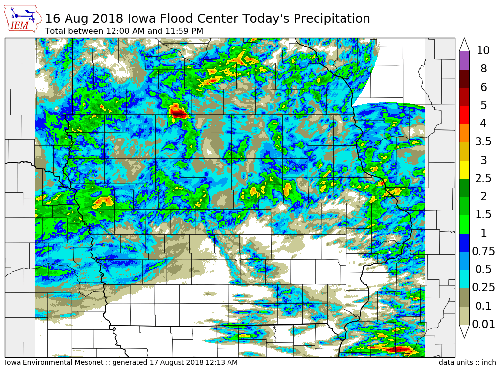
17 Aug 2018 05:35 AM
Showers and Thunderstorms were plentiful over the state on Thursday, but not everybody got rain. The featured map is of estimated precipitation totals derived from RADAR for the day from the Iowa Flood Center. A rather blotchy map presentation is shown and as has been typical for much of this summer, areas over southern Iowa mostly missed out on the action. The best chances for rain over the area arrive next week.
Voting: Good - 12 Bad - 3
Generate This Chart on Website
Mon Aug 20, 2018

August Winds
20 Aug 2018 05:34 AM
The featured chart displays a simple hourly averaged wind speed by month for Ames. The month of August shows up as the lowest value for just about every hour of the day. The light winds are one of the reasons the summer heat can feel the most oppressive during this month. Winds on Sunday were generally light over the state, but will be on the increase for Monday with a passing storm system. There are many interesting climatology features shown by this chart including a clear diurnal signal as solar heating of the ground drives vertical mixing of the air, which mixes down higher speed air aloft to the surface.
Voting: Good - 8 Bad - 0
Generate This Chart on Website
Tue Aug 21, 2018
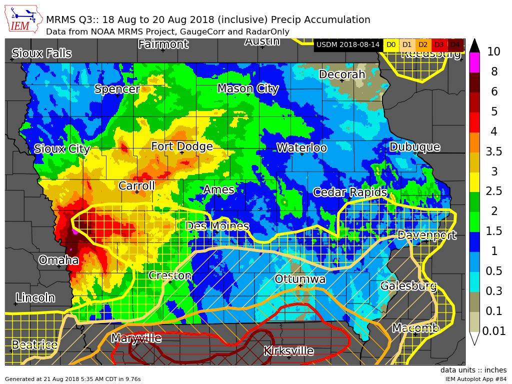
Another Big August Rainfall
21 Aug 2018 05:37 AM
Another big rainfall event this August impacted the state with the featured map depicting rainfall estimates since Saturday and the US Drought Monitor overlain. Just to our west, Omaha, NE nearly set its one-day rainfall record with a total over six inches on Monday. Some portions of extreme southern Iowa again missed out on the most significant rains, but some recently dry areas picked up needed rain. The expansion of drought coverage that was done last week will likely be mostly reverted this week. The worst off areas for drought near and south of Ottumwa really missed out again.
Voting: Good - 13 Bad - 0
Generate This Chart on Website
Wed Aug 22, 2018
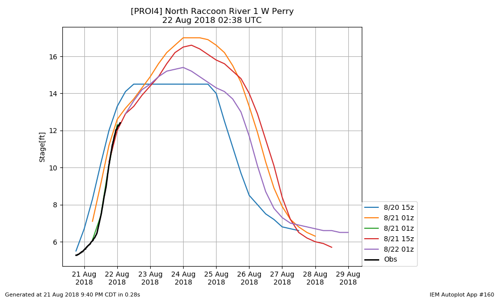
River Stage Forecasting
22 Aug 2018 05:35 AM
The recent significant rainfall over west central Iowa has some area rivers on the rise with some minor flooding expected. The National Weather Service produces river stage forecasts based on hydrology models and very near term forecasted rainfall. These forecasts can be updated multiple times per day. The featured chart looks at the forecasted and observed stage for the "1 West of Perry" site along the North Raccoon River. The black line represents the observations and the other lines are recent forecasts. The forecasts change as better data is made available and the ongoing event is better understood. You can find forecasts like these and much more on the excellent NWS AHPS Website.
Voting: Good - 8 Bad - 0
Tags: stage
Generate This Chart on Website
Thu Aug 23, 2018
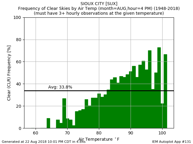
Clear Skies and 70s in August
23 Aug 2018 05:33 AM
The weather in Iowa on Wednesday was about as nice as one can expect in August. We had the rare combination of clear skies, low humidities, and temperatures in the 70s. The featured chart looks into the combination of clear skies and temperature for 4 PM August observations for Sioux City. The observation on Wednesday was 74 degrees and clear skies at the time. The featured chart indicates that less than 20% of the time when the temperature was at that level there were clear skies present. The chart indicates the intuitive relationship that clear skies tend to support hotter temperatures.
Voting: Good - 8 Bad - 0
Tags: aug
Generate This Chart on Website
Fri Aug 24, 2018

D3 Drought Frequency
24 Aug 2018 05:34 AM
The weekly release of the US Drought Monitor was yesterday and it showed a continuing degradation over southern Iowa. The area analyzed as "D3: Extreme Drought" was expanded slightly. The featured map looks at the frequency expressed as number of weeks since the year 2000 that a given location was at D3 or worse drought status. There is a sliver of white shown over far northeastern Iowa, which indicates no D3 was present since 2000. If this map was expressed in percentage of all weeks, values would be less than 5%. This level of drought is not all that common in the hence, hence the Extreme label.
Voting: Good - 11 Bad - 1
Tags: drought
Generate This Chart on Website
Mon Aug 27, 2018

Uncomfortable Humidity Returns
27 Aug 2018 05:33 AM
Humidity returned in a big way to Iowa over this past weekend with dew points well into the 70s on Sunday. The Cedar Rapids airport topped out at 77 degrees for a dew point, which was the highest value since early July as shown by the featured chart. The chart depicts the daily range between the minimum and maximum reported dew point temperature for the site. Any days at or above 77 degrees are highlighted in red. The full year depiction has a remarkable 'jump' around the first of May. This plot sort of resembles what you would see at a location that is subject to seasonal monsoons. In this case, recall how cold and snowy April was and then a switch was flipped and we made it into late spring and summer humidity levels.
Voting: Good - 10 Bad - 0
Generate This Chart on Website
Tue Aug 28, 2018

2018 Severe T'Storm Warnings
28 Aug 2018 05:33 AM
Thunderstorms impacted Iowa on Sunday and again on Monday with an encore expected on Tuesday. Some of these storms warranted warnings, which are issued by the National Weather Service for distinct spatial polygon regions (called Storm Based Warnings). The featured map presents an accounting of the number of warnings per location in the state (discretized on a 1/100 of a degree grid). The locations in white are indicated to have gotten zero Severe Thunderstorm Warnings so far this year. The most active location on this map is northeastern Calhoun County. You can generate maps like this on the website for other locations, times, and severe phenomena of your choice!
Voting: Good - 12 Bad - 0
Tags: 2018 warnings
Generate This Chart on Website
Wed Aug 29, 2018

2018 Corn Crop Condition
29 Aug 2018 05:34 AM
The featured chart displays weekly USDA NASS corn crop condition reports. The values plotted are the combined crop acres estimated to be in either Poor or Very Poor condition. The individual charts show each year's time series since 1986, with this year and two recent years highlighted. Of course, 2012 was the major drought year. This year compares favorably for each state plotted except Missouri. Of those plotted, Missouri has seen the most intense drought conditions this year.
Voting: Good - 9 Bad - 0
Tags: nass
Generate This Chart on Website
Thu Aug 30, 2018
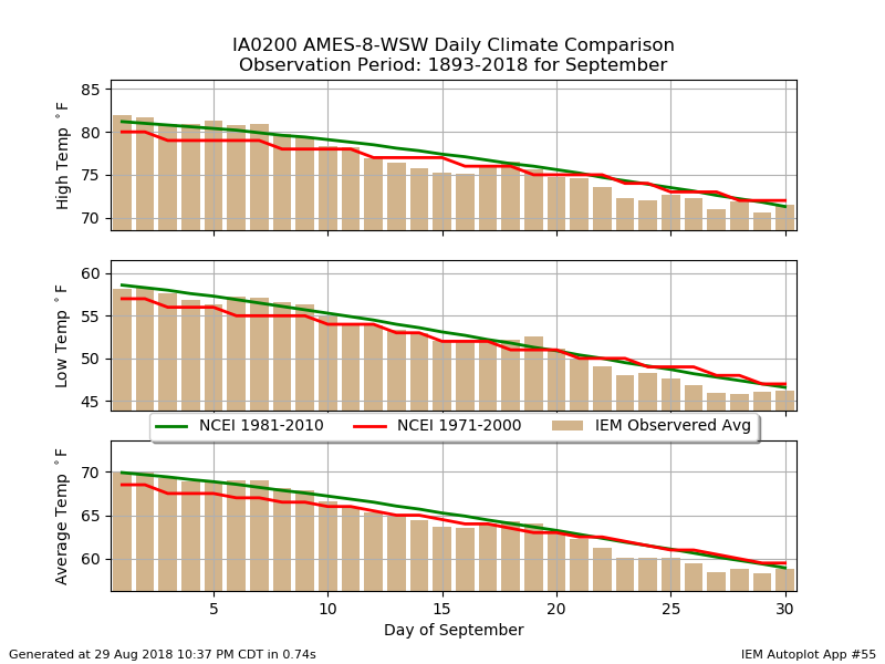
Upcoming September Slide
30 Aug 2018 05:33 AM
After a sticky and stormy Tuesday, the weather felt amazing on Wednesday with sunshine, low humidity, and low 70s temperatures. It certainly felt like fall and a reminder that September is only two days away. The featured chart looks at the daily temperature climatology for Ames for September. Three different climatologies are shown as NCEI updates their standard climate period every ten years and the IEM generates a simple arithmetic average for each calendar date over the period of record. Regardless of the metric, the temperatures clearly slide downward for the month. We loose about 10 degrees of temperature from the start to the end of the month.
Voting: Good - 7 Bad - 1
Tags: climate
Generate This Chart on Website
Fri Aug 31, 2018

Seven Inches in Seven Days
31 Aug 2018 05:35 AM
The featured map presents a remarkable precipitation forecast from the Weather Prediction Center for the next seven days. This map also contains the most recent US Drought Monitor analysis. An incredible amount of rain is predicted to fall over this period with an analyzed bullseye over seven inches depicted over southwestern Iowa. Much of the state is shown in the four plus inch range. But sadly the heaviest totals are predicted to miss the driest areas of the state again. All of this rain is thanks to a weather pattern setup that favors daytime thunderstorms and overnight storm complexes focused into the state. This pattern looks to remain at least until the end of next week!
Voting: Good - 16 Bad - 0
Generate This Chart on Website